Carapeguá night lights from space
Night Light of Carapeguá (Paraguarí) from space (Paraguay) Src. Average luminocity for 10x10km area is 8.6458% and for 50x50km: 2.7556%.
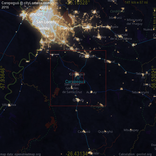
Analysis of Carapeguá night lights 2016
Square area 10x10 km:
 0.19%
0.19%90-99
0.57%80-89
0.95%70-79
1.14%60-69
3.98%50-59
0.19%40-49
1.52%30-39
3.6%20-29
0.76%10-19
0.76%0-9
86.36%Square area 50x50 km:
0.07%90-99
0.12%80-89
0.56%70-79
0.33%60-69
0.63%50-59
0.25%40-49
0.62%30-39
0.83%20-29
0.27%10-19
0.74%0-9
95.58%Clear (daylight) street map image can be seen on geolist.org.
Map coordinates:
25° 9' 55" South, 57° 56' 11.3" West
25° 48' 0" South, 57° 13' 60" West
26° 25' 52.8" South, 56° 31' 48.8" West
Some cities around Carapeguá sort by population:
• Itauguá
46.9 km =29.1 mi,  345°
345°
• Itá
35.9 km =22.3 mi,  338°
338°
• Piribebuy
41.9 km =26 mi,  27°
27°
• Paraguarí
21.7 km =13.5 mi,  23°
23°
• Ypacarai
44 km =27.3 mi, 352°
• Guarambaré
41 km =25.5 mi,  327°
327°
• Yaguarón
27 km =16.8 mi, 349°
• Quiindy
19.6 km =12.2 mi,  180°
180°
3439167 (p: 5,784)
Sources (retrieved 2019-11-25):
» Earth at Night: Flat Maps 2012, 2016