Nanawua night lights from space
Night Light of Nanawua (Presidente Hayes) from space (Paraguay) Src. Average luminocity for 10x10km area is 56.7718% and for 50x50km: 28.5864%.
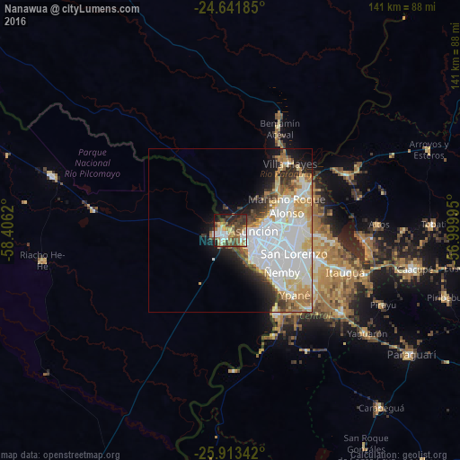
Analysis of Nanawua night lights 2016
Square area 10x10 km:
 10.32%
90-99
10.52%80-89
5.36%70-79
8.13%60-69
9.33%50-59
10.32%40-49
14.48%30-39
10.52%20-29
11.31%10-19
9.52%0-9
0.2%Square area 50x50 km:
11.03%90-99
6.18%80-89
3.12%70-79
3.03%60-69
2.71%50-59
1.79%40-49
2.43%30-39
2.45%20-29
3.22%10-19
6.13%0-9
57.9%Clear (daylight) street map image can be seen on geolist.org.
Map coordinates:
24° 38' 30.7" South, 58° 24' 22.3" West
25° 16' 45.5" South, 57° 42' 11.1" West
25° 54' 48.3" South, 56° 59' 59.8" West
Some cities around Nanawua sort by population:
• Asunción
5.7 km =3.5 mi,  98°
98°
• San Lorenzo
20.7 km =12.9 mi,  108°
108°
• Lambaré
12.3 km =7.6 mi,  127°
127°
• Fernando de la Mora
19.4 km =12.1 mi, 109°
• Nemby
21.2 km =13.2 mi, 127°
• Mariano Roque Alonso
18.9 km =11.7 mi,  65°
65°
• Villa Elisa
14.8 km =9.2 mi, 131°
• Clorinda, AR
1.7 km =1.1 mi,  248°
248°
3437696 (p: 5,587)
Sources (retrieved 2019-11-25):
» Earth at Night: Flat Maps 2012, 2016