Clorinda night lights from space
Night Light of Clorinda (Formosa) from space (Argentina) Src. Average luminocity for 10x10km area is 50.9821% and for 50x50km: 26.2703%.
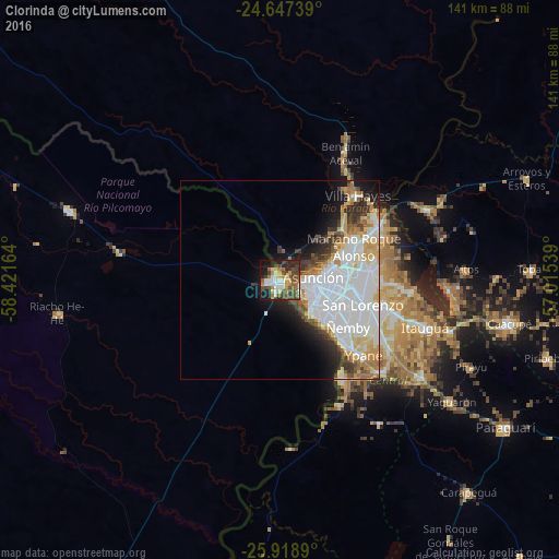
Analysis of Clorinda night lights 2016
Square area 10x10 km:
 7.14%
7.14%90-99
8.53%80-89
5.16%70-79
7.14%60-69
8.73%50-59
9.52%40-49
16.07%30-39
8.33%20-29
10.52%10-19
17.26%0-9
1.59%Square area 50x50 km:
10.54%90-99
5.51%80-89
2.56%70-79
2.56%60-69
2.31%50-59
1.74%40-49
2.41%30-39
2.45%20-29
3.16%10-19
5.88%0-9
60.87%Clear (daylight) street map image can be seen on geolist.org.
Map coordinates:
24° 38' 50.6" South, 58° 25' 17.9" West
25° 17' 5.3" South, 57° 43' 6.6" West
25° 55' 8" South, 57° 0' 55.4" West
Some cities around Clorinda sort by population:
• Asunción, PY
7.2 km =4.5 mi,  91°
91°
• San Lorenzo, PY
21.9 km =13.6 mi,  106°
106°
• Lambaré, PY
13.2 km =8.2 mi,  121°
121°
• Fernando de la Mora, PY
20.7 km =12.9 mi, 106°
• Nemby, PY
22.1 km =13.7 mi, 123°
• Mariano Roque Alonso, PY
20.6 km =12.8 mi,  65°
65°
• Villa Elisa, PY
15.6 km =9.7 mi,  126°
126°
• Nanawua, PY
1.7 km =1.1 mi, 68°
3435364 (p: 15,000)
Sources (retrieved 2019-11-25):
» Earth at Night: Flat Maps 2012, 2016