Vila Nova da Barquinha night lights from space
Night Light of Vila Nova da Barquinha (Santarém) from space (Portugal) Src. Average luminocity for 10x10km area is 37.3571% and for 50x50km: 19.3505%.
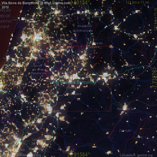
Analysis of Vila Nova da Barquinha night lights 2016
Square area 10x10 km:
 6.12%
6.12%90-99
9.35%80-89
3.91%70-79
4.59%60-69
1.53%50-59
2.38%40-49
1.36%30-39
3.06%20-29
22.96%10-19
42.01%0-9
2.72%Square area 50x50 km:
1.46%90-99
2.86%80-89
1.99%70-79
2.04%60-69
2.49%50-59
2.77%40-49
2.65%30-39
3.09%20-29
7.66%10-19
24.9%0-9
48.09%Clear (daylight) street map image can be seen on geolist.org.
Map coordinates:
40° 0' 5.5" North, 9° 8' 20.4" West
39° 27' 38.9" North, 8° 26' 9.2" West
38° 54' 57" North, 7° 43' 57.9" West
Some cities around Vila Nova da Barquinha sort by population:
• Monsanto
23.7 km =14.7 mi,  270°
270°
• Entroncamento
2.7 km =1.7 mi,  283°
283°
• Tomar
15.9 km =9.9 mi,  8°
8°
• Torres Novas
9.4 km =5.8 mi, 280°
• Abrantes
20.3 km =12.6 mi,  88°
88°
• Ourém
24.2 km =15 mi,  326°
326°
• Fátima
25.7 km =16 mi,  313°
313°
• Riachos
7 km =4.3 mi,  255°
255°
2261620 (p: 7,322)
Sources (retrieved 2019-11-25):
» Earth at Night: Flat Maps 2012, 2016