Abrantes night lights from space
Night Light of Abrantes (Santarém) from space (Portugal) Src. Average luminocity for 10x10km area is 41.2976% and for 50x50km: 10.9534%.
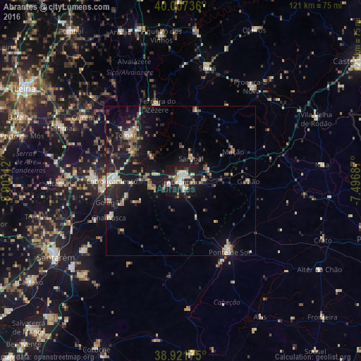
Analysis of Abrantes night lights 2016
Square area 10x10 km:
 6.8%
6.8%90-99
12.07%80-89
5.27%70-79
3.57%60-69
3.06%50-59
2.21%40-49
2.38%30-39
5.95%20-29
14.63%10-19
41.84%0-9
2.21%Square area 50x50 km:
0.83%90-99
1.59%80-89
1.31%70-79
1.17%60-69
1.32%50-59
1.49%40-49
1.09%30-39
1.88%20-29
3.89%10-19
12.84%0-9
72.6%Clear (daylight) street map image can be seen on geolist.org.
Map coordinates:
40° 0' 26.5" North, 8° 54' 11.2" West
39° 28' 0" North, 8° 12' 0" West
38° 55' 18.3" North, 7° 29' 48.7" West
Some cities around Abrantes sort by population:
• Entroncamento
22.9 km =14.2 mi,  270°
270°
• Tomar
23.4 km =14.5 mi,  309°
309°
• Torres Novas
29.5 km =18.3 mi, 271°
• Ourém
38.8 km =24.1 mi,  300°
300°
• Ponte de Sôr
29.1 km =18.1 mi,  145°
145°
• Vila Nova da Barquinha
20.3 km =12.6 mi, 268°
• Sertã
38.3 km =23.8 mi,  13°
13°
• Riachos
27.1 km =16.8 mi,  264°
264°
2272447 (p: 13,646)
Sources (retrieved 2019-11-25):
» Earth at Night: Flat Maps 2012, 2016