Riachos night lights from space
Night Light of Riachos (Santarém) from space (Portugal) Src. Average luminocity for 10x10km area is 49.6837% and for 50x50km: 20.0887%.
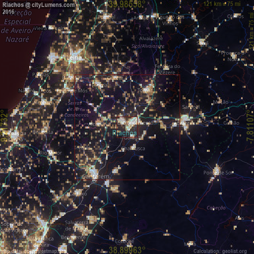
Analysis of Riachos night lights 2016
Square area 10x10 km:
 9.18%
9.18%90-99
12.41%80-89
7.82%70-79
4.93%60-69
5.44%50-59
3.91%40-49
3.06%30-39
6.12%20-29
26.19%10-19
19.73%0-9
1.19%Square area 50x50 km:
1.29%90-99
2.56%80-89
1.97%70-79
2.16%60-69
2.65%50-59
3.08%40-49
3.02%30-39
3.56%20-29
8.37%10-19
26.47%0-9
44.87%Clear (daylight) street map image can be seen on geolist.org.
Map coordinates:
39° 59' 8.1" North, 9° 13' 2.4" West
39° 26' 41" North, 8° 30' 51.1" West
38° 53' 58.7" North, 7° 48' 39.9" West
Some cities around Riachos sort by population:
• Monsanto
17.1 km =10.6 mi,  276°
276°
• Entroncamento
4.8 km =3 mi,  59°
59°
• Tomar
19.7 km =12.2 mi,  27°
27°
• Torres Novas
4.3 km =2.7 mi,  323°
323°
• Ourém
22.9 km =14.2 mi,  343°
343°
• Fátima
22.9 km =14.2 mi,  328°
328°
• Alpiarça
21.7 km =13.5 mi,  195°
195°
• Vila Nova da Barquinha
7 km =4.3 mi,  75°
75°
2263923 (p: 5,463)
Sources (retrieved 2019-11-25):
» Earth at Night: Flat Maps 2012, 2016