Viseu night lights from space
Night Light of Viseu from space (Portugal) Src. Average luminocity for 10x10km area is 68.9107% and for 50x50km: 12.881%.
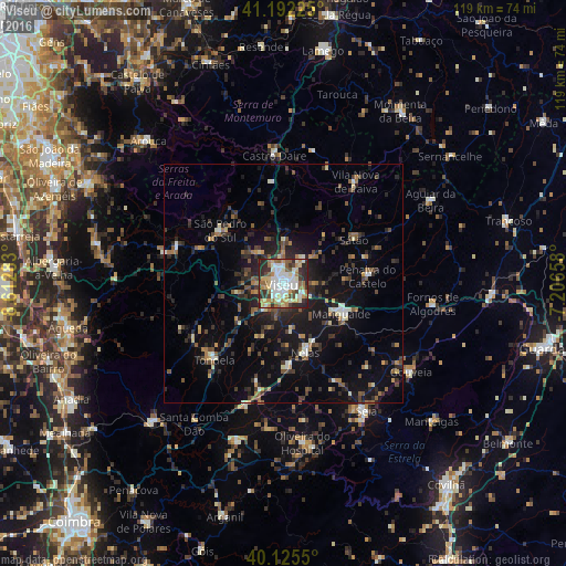
Analysis of Viseu night lights 2016
Square area 10x10 km:
 17.05%
90-99
19.32%80-89
7.63%70-79
11.2%60-69
7.63%50-59
9.09%40-49
5.52%30-39
7.95%20-29
14.45%10-19
0.16%0-9
0%Square area 50x50 km:
1.02%90-99
1.66%80-89
1.13%70-79
1.08%60-69
1.68%50-59
2.2%40-49
1.93%30-39
2.83%20-29
4.64%10-19
10.04%0-9
71.78%Clear (daylight) street map image can be seen on geolist.org.
Map coordinates:
41° 11' 32.1" North, 8° 36' 46.2" West
40° 39' 39.6" North, 7° 54' 35" West
40° 7' 31.8" North, 7° 12' 23.7" West
Some cities around Viseu sort by population:
• Rio de Loba
2.7 km =1.7 mi,  78°
78°
• Abraveses
2.5 km =1.6 mi,  337°
337°
• Mangualde
14 km =8.7 mi,  116°
116°
• Tondela
21.6 km =13.4 mi,  222°
222°
• Seia
32.2 km =20 mi,  148°
148°
• São Romão
33.3 km =20.7 mi, 150°
• Carregal do Sal
26.4 km =16.4 mi,  196°
196°
• Vila Nova de Paiva
26.3 km =16.3 mi,  35°
35°
2732265 (p: 26,364)
Sources (retrieved 2019-11-25):
» Earth at Night: Flat Maps 2012, 2016