Santa Iria da Azóia night lights from space
Night Light of Santa Iria da Azóia (Lisbon) from space (Portugal) Src. Average luminocity for 10x10km area is 78.085% and for 50x50km: 49.8166%.
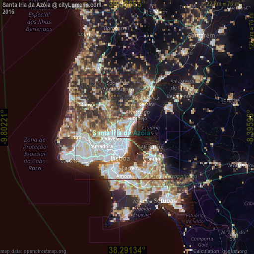
Analysis of Santa Iria da Azóia night lights 2016
Square area 10x10 km:
 30.27%
90-99
24.32%80-89
4.08%70-79
9.69%60-69
7.14%50-59
5.61%40-49
3.74%30-39
6.29%20-29
7.48%10-19
1.36%0-9
0%Square area 50x50 km:
14.32%90-99
10.92%80-89
4.48%70-79
4.33%60-69
6.48%50-59
6.35%40-49
5.86%30-39
8.05%20-29
11.53%10-19
11.15%0-9
16.54%Clear (daylight) street map image can be seen on geolist.org.
Map coordinates:
39° 23' 11.9" North, 9° 48' 8" West
38° 50' 28" North, 9° 5' 56.7" West
38° 17' 28.8" North, 8° 23' 45.5" West
Some cities around Santa Iria da Azóia sort by population:
• Póvoa de Santa Iria
3.7 km =2.3 mi,  53°
53°
• Camarate
4.9 km =3 mi,  211°
211°
• São João da Talha
1.9 km =1.2 mi,  175°
175°
• Sacavém
5.5 km =3.4 mi,  188°
188°
• Vialonga
3.9 km =2.4 mi,  27°
27°
• Unhos
3 km =1.9 mi,  217°
217°
• Bobadela
3.7 km =2.3 mi, 180°
• Apelação
4.2 km =2.6 mi, 223°
2263523 (p: 18,573)
Sources (retrieved 2019-11-25):
» Earth at Night: Flat Maps 2012, 2016