Unhos night lights from space
Night Light of Unhos (Lisbon) from space (Portugal) Src. Average luminocity for 10x10km area is 88.3231% and for 50x50km: 52.24%.
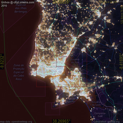
Analysis of Unhos night lights 2016
Square area 10x10 km:
 47.62%
90-99
23.98%80-89
3.91%70-79
8.16%60-69
4.76%50-59
3.4%40-49
2.04%30-39
5.78%20-29
0.34%10-19
0%0-9
0%Square area 50x50 km:
14.88%90-99
11.82%80-89
4.86%70-79
4.85%60-69
7.39%50-59
6.51%40-49
6.04%30-39
8%20-29
10.76%10-19
9.6%0-9
15.29%Clear (daylight) street map image can be seen on geolist.org.
Map coordinates:
39° 21' 55" North, 9° 49' 23.5" West
38° 49' 10.5" North, 9° 7' 12.3" West
38° 16' 10.7" North, 8° 25' 1" West
Some cities around Unhos sort by population:
• Loures
4.4 km =2.7 mi,  286°
286°
• Camarate
1.9 km =1.2 mi,  201°
201°
• São João da Talha
2 km =1.2 mi,  76°
76°
• Santa Iria da Azóia
3 km =1.9 mi,  37°
37°
• Sacavém
3.2 km =2 mi,  161°
161°
• Bobadela
2.2 km =1.4 mi,  126°
126°
• Apelação
1.2 km =0.7 mi,  238°
238°
• Prior Velho
3.1 km =1.9 mi,  181°
181°
2262465 (p: 10,712)
Sources (retrieved 2019-11-25):
» Earth at Night: Flat Maps 2012, 2016