Alpiarça night lights from space
Night Light of Alpiarça (Santarém) from space (Portugal) Src. Average luminocity for 10x10km area is 18.6905% and for 50x50km: 16.6164%.
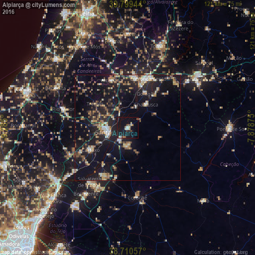
Analysis of Alpiarça night lights 2016
Square area 10x10 km:
 2.04%
2.04%90-99
2.38%80-89
2.38%70-79
1.19%60-69
1.19%50-59
2.72%40-49
1.7%30-39
1.87%20-29
1.53%10-19
36.56%0-9
46.43%Square area 50x50 km:
1.07%90-99
2.39%80-89
1.98%70-79
1.91%60-69
2.16%50-59
2.25%40-49
2.27%30-39
2.5%20-29
5.78%10-19
20.09%0-9
57.62%Clear (daylight) street map image can be seen on geolist.org.
Map coordinates:
39° 47' 58" North, 9° 17' 6" West
39° 15' 25.6" North, 8° 34' 54.7" West
38° 42' 38.1" North, 7° 52' 43.5" West
Some cities around Alpiarça sort by population:
• Monsanto
25.4 km =15.8 mi,  333°
333°
• Santarém
9.1 km =5.7 mi,  253°
253°
• Entroncamento
25.3 km =15.7 mi,  23°
23°
• Torres Novas
24.5 km =15.2 mi,  7°
7°
• Almeirim
6.6 km =4.1 mi,  215°
215°
• Cartaxo
20.7 km =12.9 mi,  238°
238°
• Fazendas de Almeirim
9.1 km =5.7 mi,  173°
173°
• Riachos
21.7 km =13.5 mi, 15°
2271878 (p: 7,946)
Sources (retrieved 2019-11-25):
» Earth at Night: Flat Maps 2012, 2016