Barcelos night lights from space
Night Light of Barcelos (Braga) from space (Portugal) Src. Average luminocity for 10x10km area is 66.7602% and for 50x50km: 46.3171%.
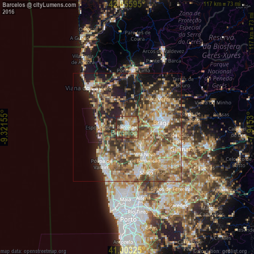
Analysis of Barcelos night lights 2016
Square area 10x10 km:
 6.97%
6.97%90-99
17.01%80-89
10.88%70-79
9.52%60-69
12.93%50-59
17.69%40-49
10.03%30-39
10.37%20-29
4.59%10-19
0%0-9
0%Square area 50x50 km:
4.26%90-99
8.79%80-89
6.7%70-79
7.48%60-69
10.91%50-59
9.56%40-49
8.53%30-39
6.38%20-29
9.4%10-19
11.21%0-9
16.78%Clear (daylight) street map image can be seen on geolist.org.
Map coordinates:
42° 3' 21.4" North, 9° 19' 17.6" West
41° 31' 54.3" North, 8° 37' 6.3" West
41° 0' 11.7" North, 7° 54' 55.1" West
Some cities around Barcelos sort by population:
• Esposende
13.6 km =8.5 mi,  272°
272°
• Semelhe
13.2 km =8.2 mi,  79°
79°
• Gondizalves
13.6 km =8.5 mi,  85°
85°
• Apúlia e Fão
13 km =8.1 mi,  260°
260°
• Aveleda
12.7 km =7.9 mi,  95°
95°
• Oliveira
13.7 km =8.5 mi,  115°
115°
• Marinhas
14 km =8.7 mi,  282°
282°
• Galegos
5.2 km =3.2 mi,  48°
48°
2742416 (p: 19,085)
Sources (retrieved 2019-11-25):
» Earth at Night: Flat Maps 2012, 2016