Caxias night lights from space
Night Light of Caxias (Lisbon) from space (Portugal) Src. Average luminocity for 10x10km area is 80.631% and for 50x50km: 44.6373%.
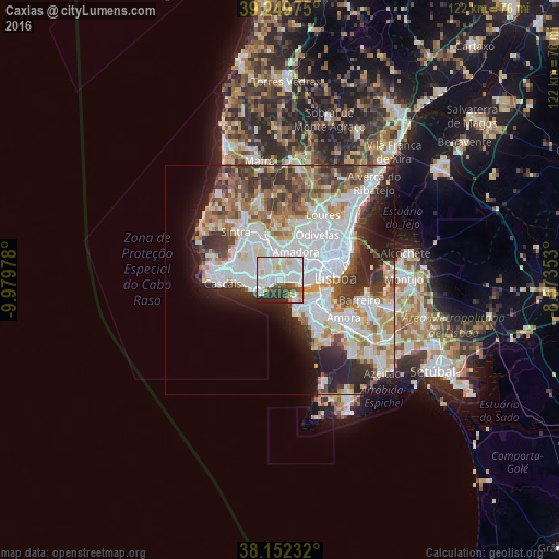
Analysis of Caxias night lights 2016
Square area 10x10 km:
 34.18%
90-99
26.36%80-89
7.99%70-79
3.4%60-69
2.55%50-59
5.27%40-49
6.29%30-39
6.97%20-29
6.97%10-19
0%0-9
0%Square area 50x50 km:
14.59%90-99
10.7%80-89
3.72%70-79
4.33%60-69
5.31%50-59
4.57%40-49
4.81%30-39
5.86%20-29
7.82%10-19
7.29%0-9
31%Clear (daylight) street map image can be seen on geolist.org.
Map coordinates:
39° 14' 59.1" North, 9° 58' 47.2" West
38° 42' 11.3" North, 9° 16' 36" West
38° 9' 8.4" North, 8° 34' 24.7" West
Some cities around Caxias sort by population:
• Oeiras
3.3 km =2.1 mi,  245°
245°
• Paço de Arcos
1.5 km =0.9 mi,  237°
237°
• Carnaxide
3.7 km =2.3 mi,  44°
44°
• Linda-a-Velha
3.2 km =2 mi,  67°
67°
• Algés
4.1 km =2.5 mi,  91°
91°
• Porto Salvo
3.3 km =2.1 mi,  312°
312°
• Barcarena
3.3 km =2.1 mi,  354°
354°
• Queijas
2.2 km =1.4 mi,  34°
34°
2269449 (p: 9,007)
Sources (retrieved 2019-11-25):
» Earth at Night: Flat Maps 2012, 2016