Algés night lights from space
Night Light of Algés (Lisbon) from space (Portugal) Src. Average luminocity for 10x10km area is 85.7959% and for 50x50km: 48.0643%.
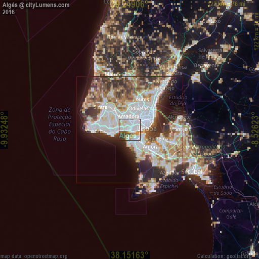
Analysis of Algés night lights 2016
Square area 10x10 km:
 46.94%
90-99
18.71%80-89
7.14%70-79
7.99%60-69
2.89%50-59
4.42%40-49
4.93%30-39
5.1%20-29
1.87%10-19
0%0-9
0%Square area 50x50 km:
15.16%90-99
11.82%80-89
4.17%70-79
4.64%60-69
5.96%50-59
5.02%40-49
5.03%30-39
6.12%20-29
8.38%10-19
8.26%0-9
25.43%Clear (daylight) street map image can be seen on geolist.org.
Map coordinates:
39° 14' 56.6" North, 9° 55' 56.9" West
38° 42' 8.8" North, 9° 13' 45.7" West
38° 9' 5.9" North, 8° 31' 34.4" West
Some cities around Algés sort by population:
• Paço de Arcos
5.4 km =3.4 mi,  262°
262°
• Carnaxide
3.1 km =1.9 mi,  331°
331°
• Caparica
5.2 km =3.2 mi,  150°
150°
• Linda-a-Velha
1.7 km =1.1 mi,  320°
320°
• Alfragide
3.4 km =2.1 mi,  15°
15°
• Caxias
4.1 km =2.5 mi,  271°
271°
• Queijas
3.4 km =2.1 mi,  302°
302°
• Trafaria
3.4 km =2.1 mi,  184°
184°
2271985 (p: 19,327)
Sources (retrieved 2019-11-25):
» Earth at Night: Flat Maps 2012, 2016