Apúlia e Fão night lights from space
Night Light of Apúlia e Fão (Braga) from space (Portugal) Src. Average luminocity for 10x10km area is 40.8486% and for 50x50km: 31.1439%.
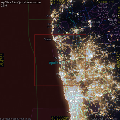
Analysis of Apúlia e Fão night lights 2016
Square area 10x10 km:
 2.72%
2.72%90-99
4.25%80-89
6.63%70-79
7.14%60-69
8.67%50-59
8.33%40-49
9.18%30-39
6.8%20-29
12.59%10-19
19.39%0-9
14.29%Square area 50x50 km:
2.69%90-99
5.44%80-89
4.39%70-79
4.7%60-69
7.2%50-59
6.92%40-49
5.57%30-39
5.31%20-29
7.77%10-19
8.51%0-9
41.49%Clear (daylight) street map image can be seen on geolist.org.
Map coordinates:
42° 2' 10.7" North, 9° 28' 33.6" West
41° 30' 43" North, 8° 46' 22.4" West
40° 58' 59.8" North, 8° 4' 11.1" West
Some cities around Apúlia e Fão sort by population:
• Esposende
2.8 km =1.7 mi,  344°
344°
• Póvoa de Varzim
14.3 km =8.9 mi,  176°
176°
• Vila do Conde
17.8 km =11.1 mi,  172°
172°
• Barcelos
13 km =8.1 mi,  80°
80°
• Pedroso
11.4 km =7.1 mi, 169°
• Aver-o-Mar
11.8 km =7.3 mi, 182°
• Marinhas
5.3 km =3.3 mi,  350°
350°
• Galegos
17.6 km =10.9 mi,  71°
71°
2739755 (p: 7,301)
Sources (retrieved 2019-11-25):
» Earth at Night: Flat Maps 2012, 2016