Cantanhede night lights from space
Night Light of Cantanhede (Coimbra) from space (Portugal) Src. Average luminocity for 10x10km area is 20.7755% and for 50x50km: 23.7728%.
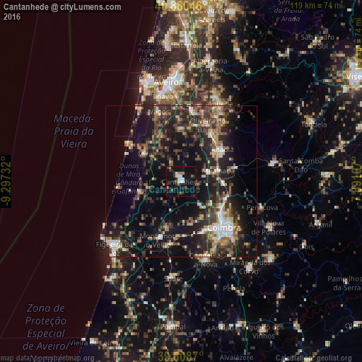
Analysis of Cantanhede night lights 2016
Square area 10x10 km:
 2.89%
2.89%90-99
2.55%80-89
1.53%70-79
1.53%60-69
1.53%50-59
2.21%40-49
2.72%30-39
4.42%20-29
4.76%10-19
29.08%0-9
46.77%Square area 50x50 km:
2.14%90-99
3.16%80-89
2.2%70-79
2.24%60-69
3.54%50-59
4.35%40-49
3.51%30-39
5.74%20-29
10.43%10-19
20.42%0-9
42.28%Clear (daylight) street map image can be seen on geolist.org.
Map coordinates:
40° 52' 49.7" North, 9° 17' 50.4" West
40° 20' 48.2" North, 8° 35' 39.1" West
39° 48' 31.3" North, 7° 53' 27.9" West
Some cities around Cantanhede sort by population:
• Coimbra
21.6 km =13.4 mi,  136°
136°
• Santo António dos Olivais
21.5 km =13.4 mi,  131°
131°
• Santa Clara
20.9 km =13 mi, 141°
• Mira
15.2 km =9.4 mi,  306°
306°
• Oiã
22.3 km =13.9 mi,  12°
12°
• Arcos
17.1 km =10.6 mi,  48°
48°
• Oliveira do Bairro
20.5 km =12.7 mi,  24°
24°
• Arazede
8.2 km =5.1 mi,  215°
215°
2741547 (p: 7,347)
Sources (retrieved 2019-11-25):
» Earth at Night: Flat Maps 2012, 2016