Efrata night lights from space
Night Light of Efrata (West Bank) from space (Palestinian Territory) Src. Average luminocity for 10x10km area is 71.989% and for 50x50km: 44.4973%.
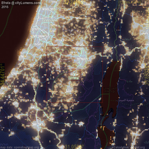
Analysis of Efrata night lights 2016
Square area 10x10 km:
 9.34%
9.34%90-99
10.26%80-89
18.68%70-79
21.61%60-69
10.07%50-59
16.85%40-49
8.24%30-39
3.3%20-29
1.65%10-19
0%0-9
0%Square area 50x50 km:
7.42%90-99
6.86%80-89
7.59%70-79
9.45%60-69
4.87%50-59
7.92%40-49
8.66%30-39
6.64%20-29
6.94%10-19
9.61%0-9
24.05%Clear (daylight) street map image can be seen on geolist.org.
Map coordinates:
32° 14' 58.7" North, 34° 26' 49.2" East
31° 39' 11" North, 35° 9' 0.5" East
31° 3' 9.4" North, 35° 51' 11.7" East
Some cities around Efrata sort by population:
• Bethlehem
7.7 km =4.8 mi,  41°
41°
• Bayt Ūmmar
5.4 km =3.4 mi,  232°
232°
• Bayt Fajjār
3.2 km =2 mi,  172°
172°
• Ad Dawḩah
5.9 km =3.7 mi,  29°
29°
• Al Khaḑir
4.8 km =3 mi,  19°
19°
• Naḩḩālīn
4.6 km =2.9 mi,  322°
322°
• Ḩūsān
6.4 km =4 mi,  346°
346°
• Jannātah
6.8 km =4.2 mi,  74°
74°
283991 (p: 10,088)
Sources (retrieved 2019-11-25):
» Earth at Night: Flat Maps 2012, 2016