Al Khaḑir night lights from space
Night Light of Al Khaḑir (West Bank) from space (Palestinian Territory) Src. Average luminocity for 10x10km area is 80.8736% and for 50x50km: 47.0722%.
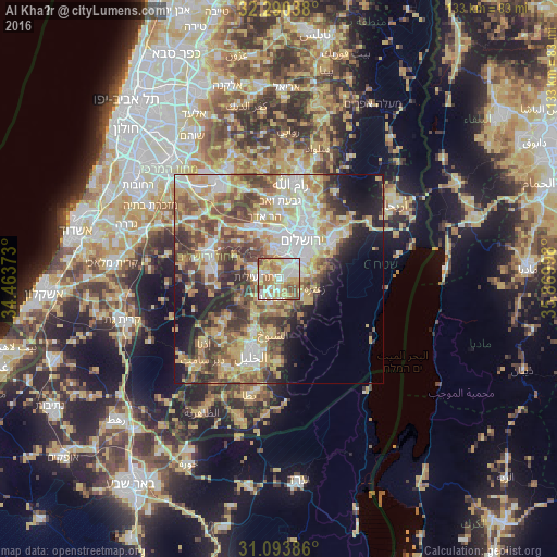
Analysis of Al Khaḑir night lights 2016
Square area 10x10 km:
 19.96%
90-99
21.06%80-89
13%70-79
18.32%60-69
12.27%50-59
11.54%40-49
3.85%30-39
0%20-29
0%10-19
0%0-9
0%Square area 50x50 km:
8.45%90-99
8.25%80-89
8.31%70-79
9.73%60-69
5.13%50-59
7.59%40-49
8.23%30-39
6.16%20-29
6.41%10-19
9.06%0-9
22.69%Clear (daylight) street map image can be seen on geolist.org.
Map coordinates:
32° 17' 25.4" North, 34° 27' 49.4" East
31° 41' 38.6" North, 35° 10' 0.7" East
31° 5' 37.9" North, 35° 52' 11.9" East
Some cities around Al Khaḑir sort by population:
• Bethlehem
3.7 km =2.3 mi,  70°
70°
• Bayt Jālā
3.1 km =1.9 mi,  39°
39°
• Bayt Sāḩūr
5.7 km =3.5 mi,  82°
82°
• Efrata
4.8 km =3 mi,  199°
199°
• Ad Dawḩah
1.4 km =0.9 mi,  64°
64°
• Naḩḩālīn
4.5 km =2.8 mi,  257°
257°
• Ḩūsān
3.5 km =2.2 mi,  299°
299°
• Jannātah
5.7 km =3.5 mi,  118°
118°
285061 (p: 9,003)
Sources (retrieved 2019-11-25):
» Earth at Night: Flat Maps 2012, 2016