Sīlat az̧ Z̧ahr night lights from space
Night Light of Sīlat az̧ Z̧ahr (West Bank) from space (Palestinian Territory) Src. Average luminocity for 10x10km area is 38.4505% and for 50x50km: 55.189%.
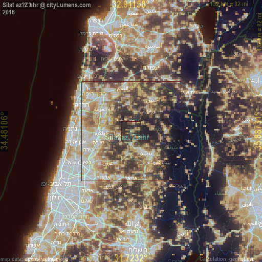
Analysis of Sīlat az̧ Z̧ahr night lights 2016
Square area 10x10 km:
 0%
0%90-99
0.37%80-89
4.76%70-79
6.41%60-69
7.69%50-59
3.85%40-49
13.74%30-39
13.92%20-29
44.69%10-19
4.58%0-9
0%Square area 50x50 km:
6.63%90-99
9.19%80-89
12.43%70-79
10.21%60-69
7.86%50-59
8.54%40-49
10.36%30-39
9.48%20-29
11.11%10-19
6.95%0-9
7.23%Clear (daylight) street map image can be seen on geolist.org.
Map coordinates:
32° 54' 41.7" North, 34° 28' 51.8" East
32° 19' 9.6" North, 35° 11' 3" East
31° 43' 23.5" North, 35° 53' 14.3" East
Some cities around Sīlat az̧ Z̧ahr sort by population:
• ‘Arrābah
9.7 km =6 mi,  9°
9°
• Jaba‘
3.5 km =2.2 mi,  81°
81°
• Kafr Rā‘ī
6.7 km =4.2 mi,  335°
335°
• ‘Anabtā
6.4 km =4 mi,  258°
258°
• Maythalūn
9.1 km =5.7 mi,  69°
69°
• ‘Illār
9.2 km =5.7 mi,  308°
308°
• Bal‘ā
7 km =4.3 mi,  283°
283°
• Bayt Līd
8.2 km =5.1 mi,  217°
217°
281790 (p: 6,079)
Sources (retrieved 2019-11-25):
» Earth at Night: Flat Maps 2012, 2016