Banī Zayd ash Shārqīyah night lights from space
Night Light of Banī Zayd ash Shārqīyah (West Bank) from space (Palestinian Territory) Src. Average luminocity for 10x10km area is 44.2045% and for 50x50km: 58.5909%.
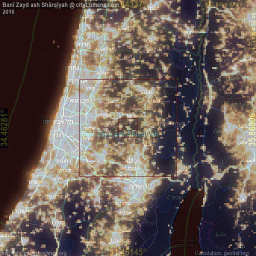
Analysis of Banī Zayd ash Shārqīyah night lights 2016
Square area 10x10 km:
 1.57%
1.57%90-99
1.4%80-89
7.17%70-79
8.74%60-69
2.1%50-59
5.59%40-49
19.93%30-39
24.3%20-29
29.2%10-19
0%0-9
0%Square area 50x50 km:
8.54%90-99
10.89%80-89
13.34%70-79
10.92%60-69
6.78%50-59
9.76%40-49
10.29%30-39
8.64%20-29
6.93%10-19
5.3%0-9
8.61%Clear (daylight) street map image can be seen on geolist.org.
Map coordinates:
32° 38' 36.1" North, 34° 27' 46.1" East
32° 2' 57.7" North, 35° 9' 57.3" East
31° 27' 5.2" North, 35° 52' 8.6" East
Some cities around Banī Zayd ash Shārqīyah sort by population:
• Ariel, IL
6.6 km =4.1 mi,  15°
15°
• Salfīt
4.1 km =2.5 mi, 20°
• Bidyā
10.9 km =6.8 mi,  311°
311°
• Silwād
12.1 km =7.5 mi,  132°
132°
• Bīr Zayt
9.3 km =5.8 mi,  163°
163°
• Jammā‘īn
9.8 km =6.1 mi, 21°
• Az Zaytūnīyah
10.6 km =6.6 mi,  181°
181°
• Sinjil
9.5 km =5.9 mi,  100°
100°
282783 (p: 5,015)
Sources (retrieved 2019-11-25):
» Earth at Night: Flat Maps 2012, 2016