Ariel night lights from space
Night Light of Ariel (Judea and Samaria Area) from space (Israel) Src. Average luminocity for 10x10km area is 51.8636% and for 50x50km: 54.4431%.
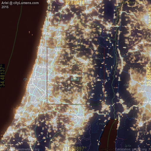
Analysis of Ariel night lights 2016
Square area 10x10 km:
 3.67%
3.67%90-99
4.9%80-89
7.52%70-79
8.92%60-69
5.42%50-59
8.04%40-49
25.52%30-39
26.4%20-29
9.62%10-19
0%0-9
0%Square area 50x50 km:
7%90-99
9.38%80-89
12.36%70-79
10.45%60-69
6.76%50-59
8.64%40-49
10.33%30-39
8.77%20-29
8.3%10-19
6.46%0-9
11.55%Clear (daylight) street map image can be seen on geolist.org.
Map coordinates:
32° 42' 0.5" North, 34° 28' 52.9" East
32° 6' 23.4" North, 35° 11' 4.2" East
31° 30' 32.3" North, 35° 53' 15.4" East
Some cities around Ariel sort by population:
• Salfīt, PS
2.6 km =1.6 mi,  187°
187°
• Baytā al Fawqā, PS
10.5 km =6.5 mi,  67°
67°
• Bidyā, PS
9.9 km =6.2 mi,  275°
275°
• Qabalān, PS
9.9 km =6.2 mi,  93°
93°
• Jammā‘īn, PS
3.3 km =2.1 mi,  33°
33°
• Ḩuwwārah, PS
8.5 km =5.3 mi,  53°
53°
• Banī Zayd, PS
10.7 km =6.6 mi,  225°
225°
• Banī Zayd ash Shārqīyah, PS
6.6 km =4.1 mi,  195°
195°
8199394 (p: 17,668)
Sources (retrieved 2019-11-25):
» Earth at Night: Flat Maps 2012, 2016