Al ‘Ayzarīyah night lights from space
Night Light of Al ‘Ayzarīyah (West Bank) from space (Palestinian Territory) Src. Average luminocity for 10x10km area is 84.4121% and for 50x50km: 43.2254%.
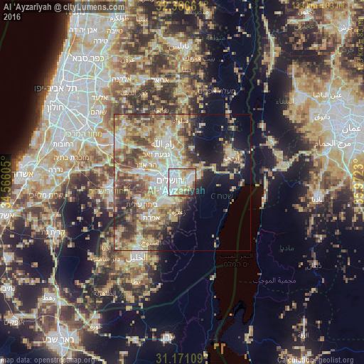
Analysis of Al ‘Ayzarīyah night lights 2016
Square area 10x10 km:
 36.81%
90-99
20.33%80-89
15.75%70-79
6.41%60-69
7.51%50-59
3.3%40-49
2.75%30-39
2.38%20-29
4.21%10-19
0.55%0-9
0%Square area 50x50 km:
7.56%90-99
7.35%80-89
8.28%70-79
8.95%60-69
4.68%50-59
6.72%40-49
6.91%30-39
5.59%20-29
5.8%10-19
8.64%0-9
29.52%Clear (daylight) street map image can be seen on geolist.org.
Map coordinates:
32° 21' 59.8" North, 34° 33' 57.8" East
31° 46' 14.8" North, 35° 16' 9" East
31° 10' 15.9" North, 35° 58' 20.3" East
Some cities around Al ‘Ayzarīyah sort by population:
• Jerusalem, IL
5 km =3.1 mi,  267°
267°
• East Jerusalem
3.6 km =2.2 mi,  292°
292°
• West Jerusalem, IL
4.8 km =3 mi,  284°
284°
• Old City
3.4 km =2.1 mi, 281°
• ‘Anātā
4.4 km =2.7 mi,  347°
347°
• Abū Dīs
1.2 km =0.7 mi,  216°
216°
• Al ‘Ubaydīyah
6.3 km =3.9 mi,  161°
161°
• Ḩizmā
7 km =4.3 mi,  355°
355°
285111 (p: 17,455)
Sources (retrieved 2019-11-25):
» Earth at Night: Flat Maps 2012, 2016