Gurabo night lights from space
Night Light of Gurabo from space (Puerto Rico) Src. Average luminocity for 10x10km area is 66.3831% and for 50x50km: 46.193%.
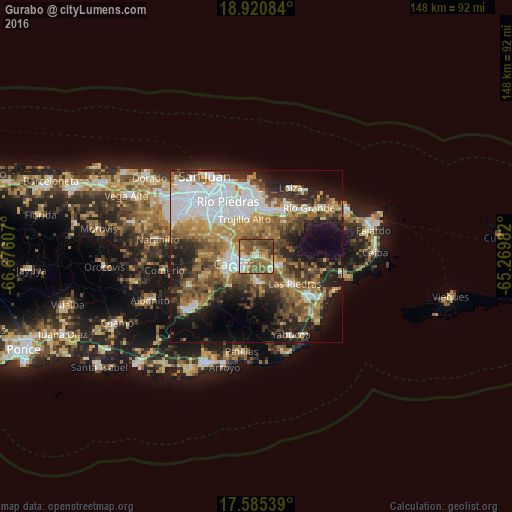
Analysis of Gurabo night lights 2016
Square area 10x10 km:
 7.79%
7.79%90-99
11.9%80-89
6.93%70-79
9.09%60-69
19.05%50-59
25.11%40-49
16.45%30-39
3.68%20-29
0%10-19
0%0-9
0%Square area 50x50 km:
11.03%90-99
6.53%80-89
4.78%70-79
5.84%60-69
8.48%50-59
7.46%40-49
7.67%30-39
7.46%20-29
9.27%10-19
13.25%0-9
18.21%Clear (daylight) street map image can be seen on geolist.org.
Map coordinates:
18° 55' 15" North, 66° 40' 33.9" West
18° 15' 15.8" North, 65° 58' 22.6" West
17° 35' 7.4" North, 65° 16' 11.4" West
Some cities around Gurabo sort by population:
• Carolina
14.1 km =8.8 mi,  6°
6°
• Caguas
8.3 km =5.2 mi,  254°
254°
• Trujillo Alto
11.7 km =7.3 mi,  341°
341°
• San Lorenzo
7.3 km =4.5 mi,  170°
170°
• Juncos
6.2 km =3.9 mi,  118°
118°
• Canovanas
15.5 km =9.6 mi,  30°
30°
• Las Piedras
13.8 km =8.6 mi,  125°
125°
• Aguas Buenas
13.7 km =8.5 mi,  271°
271°
4565125 (p: 8,973)
Sources (retrieved 2019-11-25):
» Earth at Night: Flat Maps 2012, 2016