Aibonito night lights from space
Night Light of Aibonito from space (Puerto Rico) Src. Average luminocity for 10x10km area is 25.0974% and for 50x50km: 32.3431%.
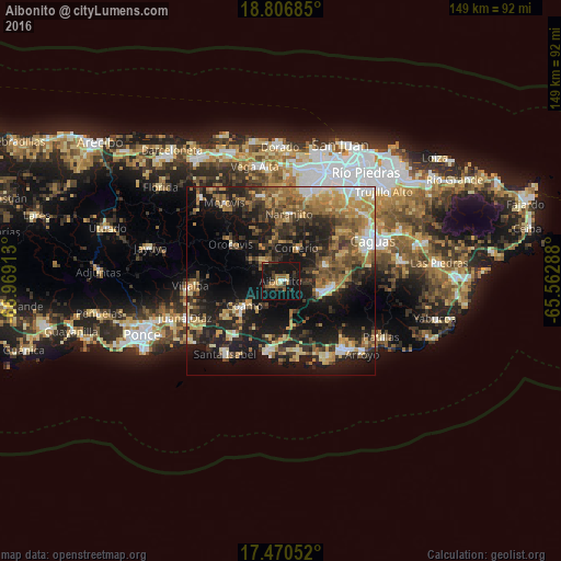
Analysis of Aibonito night lights 2016
Square area 10x10 km:
100  0.87%
0.87%
90-99 1.73%
80-89 2.38%
70-79 4.11%
60-69 3.68%
50-59 3.68%
40-49 3.46%
30-39 6.28%
20-29 4.55%
10-19 57.14%
0-9 12.12%
0.87%90-99
1.73%80-89
2.38%70-79
4.11%60-69
3.68%50-59
3.68%40-49
3.46%30-39
6.28%20-29
4.55%10-19
57.14%0-9
12.12%Square area 50x50 km:
100 2.63%
90-99 3.34%
80-89 5.06%
70-79 4.68%
60-69 6.86%
50-59 4.89%
40-49 5.13%
30-39 7.36%
20-29 10.14%
10-19 23.62%
0-9 26.28%
2.63%90-99
3.34%80-89
5.06%70-79
4.68%60-69
6.86%50-59
4.89%40-49
5.13%30-39
7.36%20-29
10.14%10-19
23.62%0-9
26.28%Clear (daylight) street map image can be seen on geolist.org.
Map coordinates:
18° 48' 24.7" North, 66° 58' 8.9" West
18° 8' 23.9" North, 66° 15' 57.6" West
17° 28' 13.9" North, 65° 33' 46.4" West
Some cities around Aibonito sort by population:
• Cayey
11 km =6.8 mi,  106°
106°
• Coamo
11.8 km =7.3 mi,  235°
235°
• Coco
14.8 km =9.2 mi,  177°
177°
• Cidra
11.8 km =7.3 mi,  70°
70°
• Comerío
9.7 km =6 mi,  25°
25°
• Barranquitas
6.7 km =4.2 mi,  320°
320°
• Naranjito
18 km =11.2 mi,  7°
7°
• Orocovis
16.4 km =10.2 mi,  306°
306°
4562529 (p: 8,947)
Sources (retrieved 2019-11-25):
» Earth at Night: Flat Maps 2012, 2016