Złotów night lights from space
Night Light of Złotów (Greater Poland) from space (Poland) Src. Average luminocity for 10x10km area is 7.9206% and for 50x50km: 1.8007%.
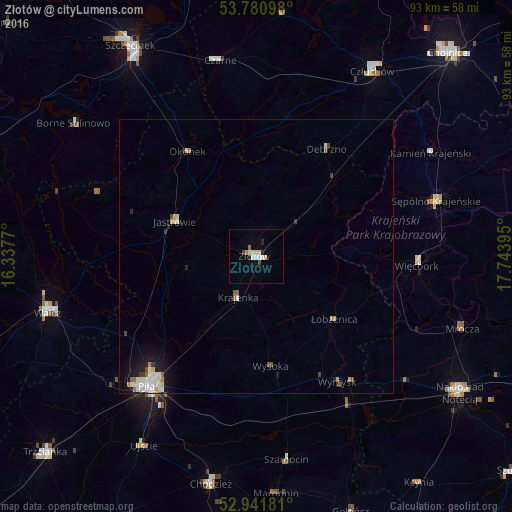
Analysis of Złotów night lights 2016
Square area 10x10 km:
 1.72%
1.72%90-99
1.72%80-89
0.79%70-79
1.06%60-69
0.53%50-59
0%40-49
0.66%30-39
0.4%20-29
1.59%10-19
0.26%0-9
91.27%Square area 50x50 km:
0.4%90-99
0.39%80-89
0.21%70-79
0.16%60-69
0.16%50-59
0.13%40-49
0.19%30-39
0.15%20-29
0.21%10-19
1.05%0-9
96.95%Clear (daylight) street map image can be seen on geolist.org.
Map coordinates:
53° 46' 51.5" North, 16° 20' 15.7" East
53° 21' 48.5" North, 17° 2' 27" East
52° 56' 30.5" North, 17° 44' 38.2" East
Some cities around Złotów sort by population:
• Piła
31 km =19.3 mi,  220°
220°
• Wałcz
39 km =24.2 mi,  255°
255°
• Sępólno Krajeńskie
34 km =21.1 mi,  73°
73°
• Jastrowie
16.1 km =10 mi,  293°
293°
• Czarne
36.3 km =22.6 mi,  349°
349°
• Więcbork
29.9 km =18.6 mi,  92°
92°
• Wyrzysk
27.9 km =17.3 mi,  147°
147°
• Debrzno
23.3 km =14.5 mi,  33°
33°
3080071 (p: 18,395)
Sources (retrieved 2019-11-25):
» Earth at Night: Flat Maps 2012, 2016