Złotoryja night lights from space
Night Light of Złotoryja (Lower Silesia) from space (Poland) Src. Average luminocity for 10x10km area is 6.1725% and for 50x50km: 4.4688%.
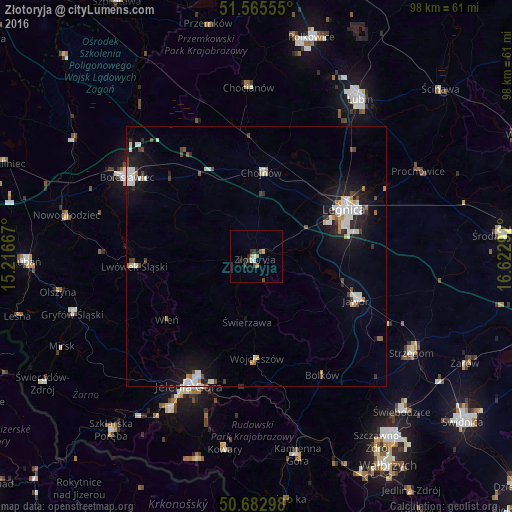
Analysis of Złotoryja night lights 2016
Square area 10x10 km:
 1.07%
1.07%90-99
0.53%80-89
0.53%70-79
0.8%60-69
0.8%50-59
1.07%40-49
0.67%30-39
1.87%20-29
1.74%10-19
0.53%0-9
90.37%Square area 50x50 km:
0.93%90-99
1.08%80-89
0.16%70-79
0.31%60-69
0.4%50-59
0.27%40-49
0.56%30-39
0.43%20-29
0.79%10-19
3.67%0-9
91.4%Clear (daylight) street map image can be seen on geolist.org.
Map coordinates:
51° 33' 56" North, 15° 13' 0" East
51° 7' 34.9" North, 15° 55' 11.2" East
50° 40' 58.7" North, 16° 37' 22.5" East
Some cities around Złotoryja sort by population:
• Legnica
19.3 km =12 mi,  61°
61°
• Jelenia Góra
28.5 km =17.7 mi,  207°
207°
• Bolesławiec
28.8 km =17.9 mi,  302°
302°
• Jawor
20.9 km =13 mi,  113°
113°
• Chojnów
16.4 km =10.2 mi,  4°
4°
• Lwówek Śląski
23.4 km =14.5 mi,  265°
265°
• Chocianów
32.5 km =20.2 mi,  357°
357°
• Bolków
26 km =16.2 mi,  150°
150°
3080074 (p: 16,612)
Sources (retrieved 2019-11-25):
» Earth at Night: Flat Maps 2012, 2016