Lwówek Śląski night lights from space
Night Light of Lwówek Śląski (Lower Silesia) from space (Poland) Src. Average luminocity for 10x10km area is 3.2848% and for 50x50km: 3.8278%.
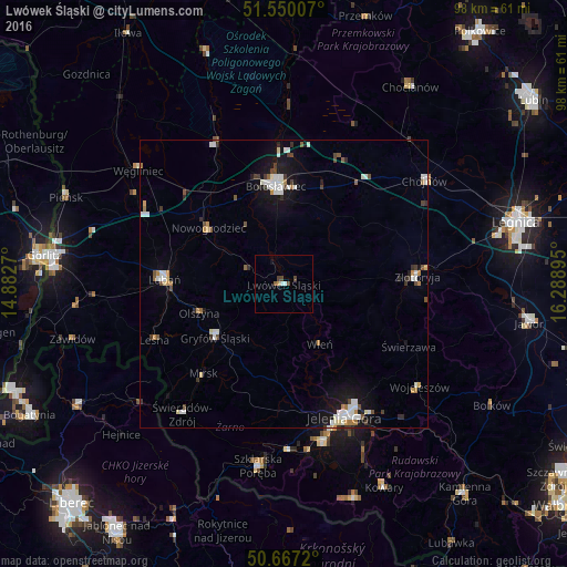
Analysis of Lwówek Śląski night lights 2016
Square area 10x10 km:
 0.53%
0.53%90-99
0.53%80-89
0.13%70-79
0.4%60-69
0%50-59
0.53%40-49
2.14%30-39
0%20-29
0%10-19
0.53%0-9
95.19%Square area 50x50 km:
0.69%90-99
0.9%80-89
0.23%70-79
0.31%60-69
0.34%50-59
0.35%40-49
0.53%30-39
0.52%20-29
0.34%10-19
2.63%0-9
93.15%Clear (daylight) street map image can be seen on geolist.org.
Map coordinates:
51° 33' 0.3" North, 14° 52' 57.7" East
51° 6' 38.7" North, 15° 35' 9" East
50° 40' 1.9" North, 16° 17' 20.2" East
Some cities around Lwówek Śląski sort by population:
• Jelenia Góra
25.5 km =15.8 mi,  156°
156°
• Bolesławiec
17.1 km =10.6 mi,  356°
356°
• Lubań
20.8 km =12.9 mi,  272°
272°
• Złotoryja
23.4 km =14.5 mi,  85°
85°
• Cieplice Śląskie Zdrój
28.1 km =17.5 mi,  165°
165°
• Chojnów
30.4 km =18.9 mi,  53°
53°
• Gryfów Śląski
14.6 km =9.1 mi,  232°
232°
• Piechowice
29 km =18 mi,  178°
178°
3092638 (p: 9,657)
Sources (retrieved 2019-11-25):
» Earth at Night: Flat Maps 2012, 2016