Chocianów night lights from space
Night Light of Chocianów (Lower Silesia) from space (Poland) Src. Average luminocity for 10x10km area is 2.6738% and for 50x50km: 4.9142%.
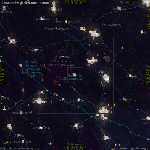
Analysis of Chocianów night lights 2016
Square area 10x10 km:
 0.27%
0.27%90-99
0.27%80-89
1.07%70-79
0%60-69
0.8%50-59
0.27%40-49
0%30-39
0.53%20-29
0%10-19
0.53%0-9
96.26%Square area 50x50 km:
1%90-99
1.11%80-89
0.2%70-79
0.22%60-69
0.42%50-59
0.35%40-49
0.57%30-39
0.51%20-29
0.68%10-19
5.16%0-9
89.79%Clear (daylight) street map image can be seen on geolist.org.
Map coordinates:
51° 51' 18.2" North, 15° 11' 55" East
51° 25' 7.2" North, 15° 54' 6.2" East
50° 58' 41.1" North, 16° 36' 17.5" East
Some cities around Chocianów sort by population:
• Legnica
29.4 km =18.3 mi,  142°
142°
• Lubin
20.9 km =13 mi,  95°
95°
• Głogów
30 km =18.6 mi,  24°
24°
• Bolesławiec
28.8 km =17.9 mi,  233°
233°
• Polkowice
15.2 km =9.4 mi,  51°
51°
• Chojnów
16.3 km =10.1 mi,  171°
171°
• Szprotawa
30.1 km =18.7 mi,  302°
302°
• Przemków
14 km =8.7 mi,  327°
327°
3101722 (p: 8,187)
Sources (retrieved 2019-11-25):
» Earth at Night: Flat Maps 2012, 2016