Zawadzkie night lights from space
Night Light of Zawadzkie (Opole Voivodeship) from space (Poland) Src. Average luminocity for 10x10km area is 1.8917% and for 50x50km: 3.5865%.
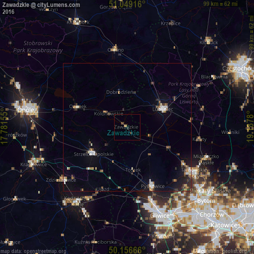
Analysis of Zawadzkie night lights 2016
Square area 10x10 km:
 0%
0%90-99
0%80-89
0%70-79
0.94%60-69
0.13%50-59
0.27%40-49
1.07%30-39
0.8%20-29
0%10-19
0%0-9
96.79%Square area 50x50 km:
0.36%90-99
0.56%80-89
0.17%70-79
0.36%60-69
0.58%50-59
0.46%40-49
0.54%30-39
0.66%20-29
0.79%10-19
2.18%0-9
93.32%Clear (daylight) street map image can be seen on geolist.org.
Map coordinates:
51° 2' 57" North, 17° 46' 53.6" East
50° 36' 18.1" North, 18° 29' 4.8" East
50° 9' 24" North, 19° 11' 16.1" East
Some cities around Zawadzkie sort by population:
• Tarnowskie Góry
32 km =19.9 mi,  123°
123°
• Lubliniec
15.8 km =9.8 mi,  63°
63°
• Strzelce Opolskie
16.7 km =10.4 mi,  231°
231°
• Pyskowice
25.1 km =15.6 mi,  155°
155°
• Zdzieszowice
32.5 km =20.2 mi, 231°
• Olesno
30.6 km =19 mi,  351°
351°
• Ozimek
20.8 km =12.9 mi,  293°
293°
• Kalety
29.2 km =18.1 mi,  99°
99°
3080538 (p: 8,439)
Sources (retrieved 2019-11-25):
» Earth at Night: Flat Maps 2012, 2016