Lubliniec night lights from space
Night Light of Lubliniec (Silesia) from space (Poland) Src. Average luminocity for 10x10km area is 14.8743% and for 50x50km: 3.2612%.

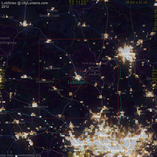
Analysis of Lubliniec night lights 2016
Square area 10x10 km:
 3.07%
3.07%90-99
2.81%80-89
1.07%70-79
0%60-69
2.01%50-59
2.14%40-49
2.27%30-39
1.6%20-29
1.2%10-19
7.22%0-9
76.6%Square area 50x50 km:
0.29%90-99
0.3%80-89
0.18%70-79
0.41%60-69
0.6%50-59
0.5%40-49
0.63%30-39
0.66%20-29
0.81%10-19
2.26%0-9
93.36%Clear (daylight) street map image can be seen on geolist.org.
Map coordinates:
51° 6' 45" North, 17° 58' 52.6" East
50° 40' 8.3" North, 18° 41' 3.8" East
50° 13' 16.4" North, 19° 23' 15.1" East
Some cities around Lubliniec sort by population:
• Tarnowskie Góry
27.8 km =17.3 mi,  153°
153°
• Pyskowice
30.1 km =18.7 mi,  186°
186°
• Kłobuck
31.3 km =19.4 mi,  34°
34°
• Olesno
29.6 km =18.4 mi,  321°
321°
• Blachownia
23.2 km =14.4 mi,  57°
57°
• Kalety
18.9 km =11.7 mi,  128°
128°
• Zawadzkie
15.8 km =9.8 mi,  243°
243°
• Miasteczko Śląskie
25.8 km =16 mi,  135°
135°
3092906 (p: 24,133)
Sources (retrieved 2019-11-25):
» Earth at Night: Flat Maps 2012, 2016