Wojszyce night lights from space
Night Light of Wojszyce (Lower Silesia) from space (Poland) Src. Average luminocity for 10x10km area is 68.9345% and for 50x50km: 16.3249%.
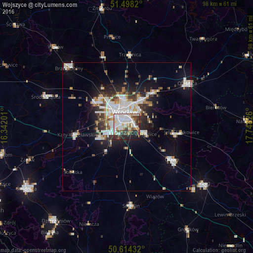
Analysis of Wojszyce night lights 2016
Square area 10x10 km:
 24.47%
90-99
20.86%80-89
5.35%70-79
3.48%60-69
5.61%50-59
4.81%40-49
8.96%30-39
8.69%20-29
11.9%10-19
5.88%0-9
0%Square area 50x50 km:
4.19%90-99
3.9%80-89
1.14%70-79
1.28%60-69
1.36%50-59
1.57%40-49
1.74%30-39
2.16%20-29
3.69%10-19
7.93%0-9
71.04%Clear (daylight) street map image can be seen on geolist.org.
Map coordinates:
51° 29' 53.5" North, 16° 20' 31.2" East
51° 3' 30.1" North, 17° 2' 42.5" East
50° 36' 51.6" North, 17° 44' 53.7" East
Some cities around Wojszyce sort by population:
• Wrocław
4.7 km =2.9 mi,  349°
349°
• Rejon ulicy Traugutta
4.9 km =3 mi,  2°
2°
• Krzyki
3.8 km =2.4 mi,  291°
291°
• Powstańców Śląskich Zachód-Centrum Południow
4.6 km =2.9 mi,  335°
335°
• Powstańców Śląskich Wschód
4 km =2.5 mi, 338°
• Rejon ulicy Mieleckiej
4.8 km =3 mi,  320°
320°
• Księże Małe-Księże Wielkie
3.5 km =2.2 mi,  62°
62°
• Osiedle Henrykowskie
3.6 km =2.2 mi,  8°
8°
12047663 (p: 5,338)
Sources (retrieved 2019-11-25):
» Earth at Night: Flat Maps 2012, 2016