Wieprz night lights from space
Night Light of Wieprz (Lesser Poland) from space (Poland) Src. Average luminocity for 10x10km area is 5.6092% and for 50x50km: 11.4737%.
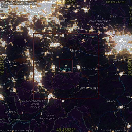
Analysis of Wieprz night lights 2016
Square area 10x10 km:
100  0.7%
0.7%
90-99 0.98%
80-89 0%
70-79 0.7%
60-69 1.54%
50-59 1.12%
40-49 1.4%
30-39 0.28%
20-29 0%
10-19 1.12%
0-9 92.16%
0.7%90-99
0.98%80-89
0%70-79
0.7%60-69
1.54%50-59
1.12%40-49
1.4%30-39
0.28%20-29
0%10-19
1.12%0-9
92.16%Square area 50x50 km:
100 2.17%
90-99 2.07%
80-89 0.61%
70-79 0.68%
60-69 1.23%
50-59 1.47%
40-49 1.62%
30-39 2.18%
20-29 3.05%
10-19 10.06%
0-9 74.84%
2.17%90-99
2.07%80-89
0.61%70-79
0.68%60-69
1.23%50-59
1.47%40-49
1.62%30-39
2.18%20-29
3.05%10-19
10.06%0-9
74.84%Clear (daylight) street map image can be seen on geolist.org.
Map coordinates:
50° 20' 30.4" North, 18° 39' 13.5" East
49° 53' 27.3" North, 19° 21' 24.8" East
49° 26' 9" North, 20° 3' 36" East
Some cities around Wieprz sort by population:
• Andrychów
4.2 km =2.6 mi,  198°
198°
• Kęty
9.6 km =6 mi,  264°
264°
• Wadowice
9.8 km =6.1 mi,  94°
94°
• Kozy
15.7 km =9.8 mi,  252°
252°
• Brzeszcze
17.8 km =11.1 mi,  304°
304°
• Osiek
9.4 km =5.8 mi,  315°
315°
• Czaniec
8.7 km =5.4 mi,  238°
238°
• Chocznia
7.2 km =4.5 mi,  104°
104°
3082192 (p: 5,002)
Sources (retrieved 2019-11-25):
» Earth at Night: Flat Maps 2012, 2016