Wadowice night lights from space
Night Light of Wadowice (Lesser Poland) from space (Poland) Src. Average luminocity for 10x10km area is 9.1597% and for 50x50km: 7.7544%.
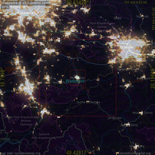
Analysis of Wadowice night lights 2016
Square area 10x10 km:
 1.4%
1.4%90-99
2.38%80-89
0.84%70-79
0.42%60-69
0.56%50-59
1.68%40-49
0%30-39
1.82%20-29
1.54%10-19
0.14%0-9
89.22%Square area 50x50 km:
0.97%90-99
1.21%80-89
0.56%70-79
0.57%60-69
1.05%50-59
1.15%40-49
1.18%30-39
1.64%20-29
1.97%10-19
7.03%0-9
82.68%Clear (daylight) street map image can be seen on geolist.org.
Map coordinates:
50° 20' 3.4" North, 18° 47' 23.3" East
49° 53' 0.1" North, 19° 29' 34.5" East
49° 25' 41.4" North, 20° 11' 45.8" East
Some cities around Wadowice sort by population:
• Andrychów
11.5 km =7.1 mi,  254°
254°
• Kęty
19.3 km =12 mi,  269°
269°
• Sucha Beskidzka
17.3 km =10.7 mi,  155°
155°
• Osiek
18 km =11.2 mi,  294°
294°
• Czaniec
17.5 km =10.9 mi,  258°
258°
• Chocznia
2.9 km =1.8 mi, 249°
• Stryszawa
19 km =11.8 mi,  173°
173°
• Wieprz
9.8 km =6.1 mi, 274°
3082722 (p: 19,238)
Sources (retrieved 2019-11-25):
» Earth at Night: Flat Maps 2012, 2016