Czaniec night lights from space
Night Light of Czaniec (Silesia) from space (Poland) Src. Average luminocity for 10x10km area is 15.0348% and for 50x50km: 12.2545%.
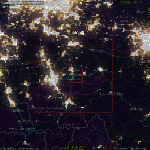
Analysis of Czaniec night lights 2016
Square area 10x10 km:
100  1.6%
1.6%
90-99 2.41%
80-89 0.67%
70-79 1.34%
60-69 3.21%
50-59 3.74%
40-49 1.87%
30-39 2.54%
20-29 0.53%
10-19 10.83%
0-9 71.26%
1.6%90-99
2.41%80-89
0.67%70-79
1.34%60-69
3.21%50-59
3.74%40-49
1.87%30-39
2.54%20-29
0.53%10-19
10.83%0-9
71.26%Square area 50x50 km:
100 2.07%
90-99 2.04%
80-89 0.73%
70-79 0.82%
60-69 1.43%
50-59 1.69%
40-49 1.96%
30-39 2.23%
20-29 3.36%
10-19 10.88%
0-9 72.81%
2.07%90-99
2.04%80-89
0.73%70-79
0.82%60-69
1.43%50-59
1.69%40-49
1.96%30-39
2.23%20-29
3.36%10-19
10.88%0-9
72.81%Clear (daylight) street map image can be seen on geolist.org.
Map coordinates:
50° 18' 7" North, 18° 33' 1.5" East
49° 51' 2.6" North, 19° 15' 12.7" East
49° 23' 42.8" North, 19° 57' 24" East
Some cities around Czaniec sort by population:
• Bielsko-Biala
15.2 km =9.4 mi,  258°
258°
• Andrychów
6.1 km =3.8 mi,  85°
85°
• Kęty
4.1 km =2.5 mi,  328°
328°
• Kozy
7.5 km =4.7 mi,  267°
267°
• Osiek
11.1 km =6.9 mi,  4°
4°
• Wilkowice
15.3 km =9.5 mi,  230°
230°
• Chocznia
14.6 km =9.1 mi,  79°
79°
• Wieprz
8.7 km =5.4 mi,  58°
58°
3101220 (p: 5,536)
Sources (retrieved 2019-11-25):
» Earth at Night: Flat Maps 2012, 2016