Chocznia night lights from space
Night Light of Chocznia (Lesser Poland) from space (Poland) Src. Average luminocity for 10x10km area is 8.4398% and for 50x50km: 7.2768%.
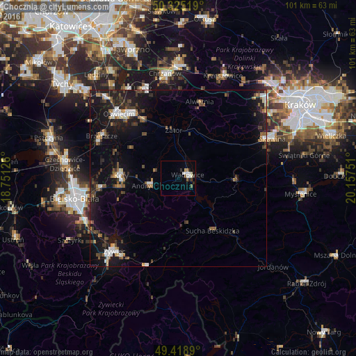
Analysis of Chocznia night lights 2016
Square area 10x10 km:
 1.34%
1.34%90-99
2.27%80-89
0.8%70-79
0.4%60-69
0.53%50-59
1.6%40-49
0%30-39
1.74%20-29
1.47%10-19
0.13%0-9
89.71%Square area 50x50 km:
0.85%90-99
1.02%80-89
0.34%70-79
0.52%60-69
0.94%50-59
1.07%40-49
1.19%30-39
1.45%20-29
1.86%10-19
8.09%0-9
82.67%Clear (daylight) street map image can be seen on geolist.org.
Map coordinates:
50° 19' 30.7" North, 18° 45' 4.5" East
49° 52' 27" North, 19° 27' 15.8" East
49° 25' 8" North, 20° 9' 27" East
Some cities around Chocznia sort by population:
• Andrychów
8.6 km =5.3 mi,  255°
255°
• Kęty
16.6 km =10.3 mi,  273°
273°
• Wadowice
2.9 km =1.8 mi,  69°
69°
• Sucha Beskidzka
17.8 km =11.1 mi,  145°
145°
• Osiek
16 km =9.9 mi,  302°
302°
• Czaniec
14.6 km =9.1 mi, 259°
• Stryszawa
18.5 km =11.5 mi,  164°
164°
• Wieprz
7.2 km =4.5 mi,  284°
284°
3101691 (p: 5,510)
Sources (retrieved 2019-11-25):
» Earth at Night: Flat Maps 2012, 2016