Stryszawa night lights from space
Night Light of Stryszawa (Lesser Poland) from space (Poland) Src. Average luminocity for 10x10km area is 0.8957% and for 50x50km: 2.5593%.
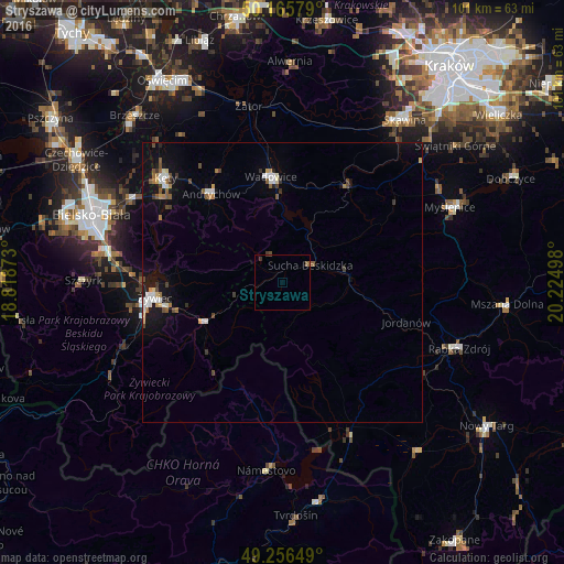
Analysis of Stryszawa night lights 2016
Square area 10x10 km:
 0%
0%90-99
0%80-89
0%70-79
0%60-69
0%50-59
0.8%40-49
0.27%30-39
0.8%20-29
0%10-19
0%0-9
98.13%Square area 50x50 km:
0.34%90-99
0.42%80-89
0.19%70-79
0.17%60-69
0.34%50-59
0.4%40-49
0.35%30-39
0.4%20-29
0.15%10-19
1.88%0-9
95.35%Clear (daylight) street map image can be seen on geolist.org.
Map coordinates:
50° 9' 56.8" North, 18° 49' 7.4" East
49° 42' 47.8" North, 19° 31' 18.7" East
49° 15' 23.4" North, 20° 13' 29.9" East
Some cities around Stryszawa sort by population:
• Andrychów
20.5 km =12.7 mi,  320°
320°
• Wadowice
19 km =11.8 mi,  353°
353°
• Sucha Beskidzka
6.1 km =3.8 mi,  58°
58°
• Zawoja
7.8 km =4.8 mi,  169°
169°
• Maków Podhalański
11.3 km =7 mi,  80°
80°
• Chocznia
18.5 km =11.5 mi,  344°
344°
• Jordanów
23.3 km =14.5 mi,  107°
107°
• Wieprz
23 km =14.3 mi,  329°
329°
3084460 (p: 5,266)
Sources (retrieved 2019-11-25):
» Earth at Night: Flat Maps 2012, 2016