Starogard Gdański night lights from space
Night Light of Starogard Gdański (Pomerania) from space (Poland) Src. Average luminocity for 10x10km area is 20.7619% and for 50x50km: 3.1062%.
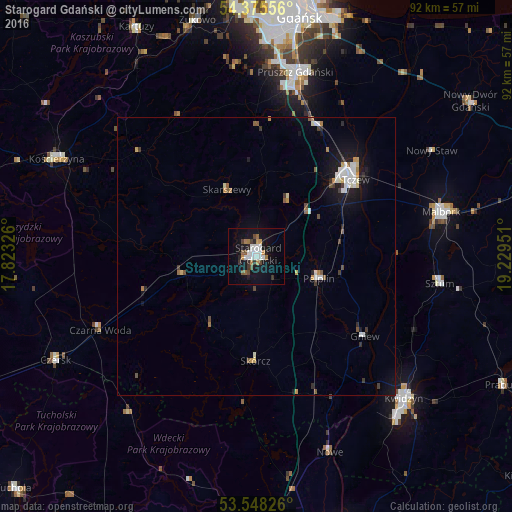

Analysis of Starogard Gdański night lights 2016
Square area 10x10 km:
 5.03%
5.03%90-99
3.44%80-89
0%70-79
1.98%60-69
2.78%50-59
2.51%40-49
3.04%30-39
2.51%20-29
2.51%10-19
20.63%0-9
55.56%Square area 50x50 km:
0.58%90-99
0.52%80-89
0.16%70-79
0.3%60-69
0.34%50-59
0.36%40-49
0.33%30-39
0.36%20-29
0.37%10-19
2.62%0-9
94.05%Clear (daylight) street map image can be seen on geolist.org.
Map coordinates:
54° 22' 32" North, 17° 49' 23.7" East
53° 57' 50.3" North, 18° 31' 35" East
53° 32' 53.7" North, 19° 13' 46.2" East
Some cities around Starogard Gdański sort by population:
• Tczew
21.8 km =13.5 mi,  48°
48°
• Malbork
33.7 km =20.9 mi,  76°
76°
• Pruszcz Gdański
33.9 km =21.1 mi,  12°
12°
• Sztum
33.4 km =20.8 mi,  98°
98°
• Pelplin
11.9 km =7.4 mi,  109°
109°
• Skarszewy
12.9 km =8 mi,  335°
335°
• Gniew
24.1 km =15 mi,  126°
126°
• Nowe
37.4 km =23.2 mi,  159°
159°
3084826 (p: 48,202)
Sources (retrieved 2019-11-25):
» Earth at Night: Flat Maps 2012, 2016