Pruszcz Gdański night lights from space
Night Light of Pruszcz Gdański (Pomerania) from space (Poland) Src. Average luminocity for 10x10km area is 44.7544% and for 50x50km: 15.014%.
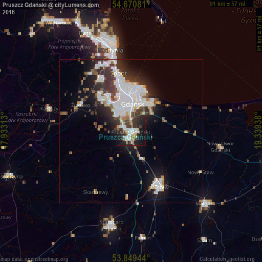

Analysis of Pruszcz Gdański night lights 2016
Square area 10x10 km:
 9.65%
9.65%90-99
10.28%80-89
1.25%70-79
4.39%60-69
6.89%50-59
4.01%40-49
6.64%30-39
11.65%20-29
15.41%10-19
21.18%0-9
8.65%Square area 50x50 km:
4.42%90-99
3.52%80-89
0.74%70-79
0.92%60-69
1.28%50-59
1.2%40-49
1.67%30-39
3%20-29
3.58%10-19
7.21%0-9
72.46%Clear (daylight) street map image can be seen on geolist.org.
Map coordinates:
54° 40' 14.9" North, 17° 55' 59.3" East
54° 15' 43.8" North, 18° 38' 10.5" East
53° 50' 58" North, 19° 20' 21.8" East
Some cities around Pruszcz Gdański sort by population:
• Gdańsk
10 km =6.2 mi,  3°
3°
• Gdynia
29.3 km =18.2 mi,  346°
346°
• Tczew
21 km =13 mi,  153°
153°
• Sopot
20.6 km =12.8 mi, 346°
• Kartuzy
29.6 km =18.4 mi,  285°
285°
• Wielki Kack
24.8 km =15.4 mi,  337°
337°
• Skarszewy
24.8 km =15.4 mi,  210°
210°
• Żukowo
19.7 km =12.2 mi,  296°
296°
3088034 (p: 23,618)
Sources (retrieved 2019-11-25):
» Earth at Night: Flat Maps 2012, 2016