Stąporków night lights from space
Night Light of Stąporków (Świętokrzyskie) from space (Poland) Src. Average luminocity for 10x10km area is 1.4278% and for 50x50km: 3.6939%.
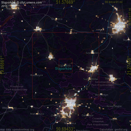
Analysis of Stąporków night lights 2016
Square area 10x10 km:
 0%
0%90-99
0%80-89
0.4%70-79
0.13%60-69
0.53%50-59
0%40-49
0.27%30-39
0.13%20-29
0.94%10-19
0.53%0-9
97.06%Square area 50x50 km:
0.47%90-99
0.64%80-89
0.18%70-79
0.34%60-69
0.42%50-59
0.6%40-49
0.53%30-39
0.33%20-29
0.89%10-19
3.19%0-9
92.41%Clear (daylight) street map image can be seen on geolist.org.
Map coordinates:
51° 34' 36.1" North, 19° 52' 7" East
51° 8' 15.4" North, 20° 34' 18.2" East
50° 41' 39.6" North, 21° 16' 29.5" East
Some cities around Stąporków sort by population:
• Kielce
30 km =18.6 mi,  172°
172°
• Starachowice
36.6 km =22.7 mi,  107°
107°
• Skarżysko-Kamienna
21.1 km =13.1 mi,  97°
97°
• Opoczno
33.4 km =20.8 mi,  322°
322°
• Końskie
13 km =8.1 mi,  297°
297°
• Szydłowiec
22.5 km =14 mi,  63°
63°
• Suchedniów
20.6 km =12.8 mi,  119°
119°
• Przysucha
24.9 km =15.5 mi,  9°
9°
758393 (p: 5,946)
Sources (retrieved 2019-11-25):
» Earth at Night: Flat Maps 2012, 2016