Stabłowice night lights from space
Night Light of Stabłowice (Lower Silesia) from space (Poland) Src. Average luminocity for 10x10km area is 50.1925% and for 50x50km: 15.4686%.
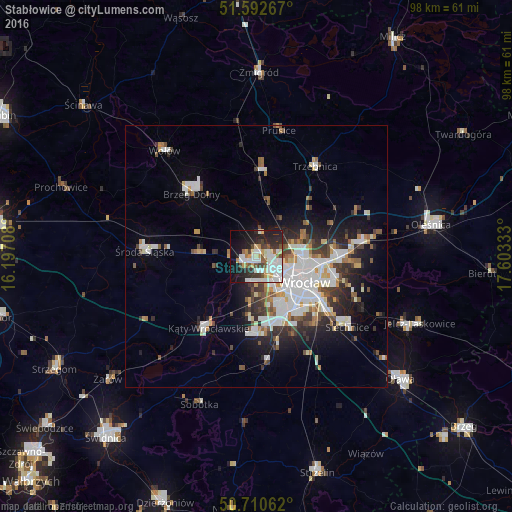
Analysis of Stabłowice night lights 2016
Square area 10x10 km:
 14.04%
90-99
15.78%80-89
3.34%70-79
4.81%60-69
2.01%50-59
4.68%40-49
4.55%30-39
5.35%20-29
13.77%10-19
20.72%0-9
10.96%Square area 50x50 km:
3.99%90-99
3.6%80-89
1.12%70-79
1.26%60-69
1.38%50-59
1.51%40-49
1.78%30-39
2.02%20-29
3.64%10-19
6.52%0-9
73.18%Clear (daylight) street map image can be seen on geolist.org.
Map coordinates:
51° 35' 33.6" North, 16° 11' 49.5" East
51° 9' 13.5" North, 16° 54' 0.7" East
50° 42' 38.2" North, 17° 36' 12" East
Some cities around Stabłowice sort by population:
• Osiedle Kosmonautów
5.2 km =3.2 mi,  124°
124°
• Kozanów
4.9 km =3 mi,  102°
102°
• Różanka-Polanka
8.4 km =5.2 mi, 97°
• Leśnica-Ratyń-Pustki
3.9 km =2.4 mi,  250°
250°
• Gądów Mały
7.2 km =4.5 mi, 123°
• Maślice Małe
2.9 km =1.8 mi, 99°
• Pilczyce
4.4 km =2.7 mi,  114°
114°
• Złotniki
1.9 km =1.2 mi,  203°
203°
12047639 (p: 14,099)
Sources (retrieved 2019-11-25):
» Earth at Night: Flat Maps 2012, 2016