Pilczyce night lights from space
Night Light of Pilczyce (Lower Silesia) from space (Poland) Src. Average luminocity for 10x10km area is 78.9693% and for 50x50km: 15.9209%.
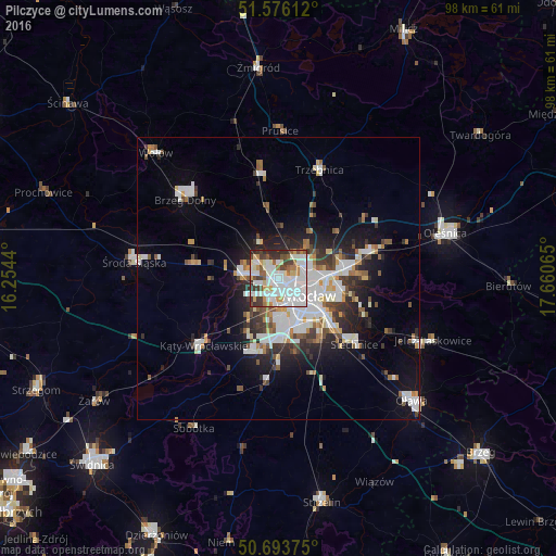
Analysis of Pilczyce night lights 2016
Square area 10x10 km:
 32.75%
90-99
24.73%80-89
4.55%70-79
6.68%60-69
4.68%50-59
6.15%40-49
6.28%30-39
8.56%20-29
5.61%10-19
0%0-9
0%Square area 50x50 km:
4.15%90-99
3.73%80-89
1.11%70-79
1.27%60-69
1.42%50-59
1.56%40-49
1.74%30-39
2.05%20-29
3.68%10-19
7.08%0-9
72.23%Clear (daylight) street map image can be seen on geolist.org.
Map coordinates:
51° 34' 34" North, 16° 15' 15.8" East
51° 8' 13.3" North, 16° 57' 27.1" East
50° 41' 37.5" North, 17° 39' 38.3" East
Some cities around Pilczyce sort by population:
• Osiedle Kosmonautów
1.1 km =0.7 mi,  164°
164°
• Kozanów
1.2 km =0.7 mi,  45°
45°
• Różanka-Polanka
4.4 km =2.7 mi,  80°
80°
• Stabłowice
4.4 km =2.7 mi,  294°
294°
• Gądów Mały
2.9 km =1.8 mi,  136°
136°
• Maślice Małe
1.8 km =1.1 mi,  321°
321°
• Rejon ulicy Klęczkowskiej
5.4 km =3.4 mi,  98°
98°
• Złotniki
4.8 km =3 mi,  270°
270°
12047630 (p: 5,582)
Sources (retrieved 2019-11-25):
» Earth at Night: Flat Maps 2012, 2016