Sędziszów Małopolski night lights from space
Night Light of Sędziszów Małopolski (Subcarpathia) from space (Poland) Src. Average luminocity for 10x10km area is 7.5476% and for 50x50km: 7.2237%.
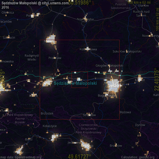
Analysis of Sędziszów Małopolski night lights 2016
Square area 10x10 km:
 2.38%
2.38%90-99
1.54%80-89
0.56%70-79
0%60-69
0.56%50-59
0.98%40-49
0.14%30-39
0%20-29
0%10-19
0.56%0-9
93.28%Square area 50x50 km:
1.62%90-99
1.7%80-89
0.52%70-79
0.57%60-69
0.79%50-59
0.47%40-49
0.57%30-39
0.73%20-29
1.94%10-19
4.58%0-9
86.51%Clear (daylight) street map image can be seen on geolist.org.
Map coordinates:
50° 31' 11.5" North, 20° 59' 51" East
50° 4' 14.5" North, 21° 42' 2.2" East
49° 37' 2.2" North, 22° 24' 13.5" East
Some cities around Sędziszów Małopolski sort by population:
• Rzeszów
21.6 km =13.4 mi,  98°
98°
• Mielec
31.1 km =19.3 mi,  320°
320°
• Dębica
20.8 km =12.9 mi,  264°
264°
• Ropczyce
6.9 km =4.3 mi,  252°
252°
• Kolbuszowa
20 km =12.4 mi,  15°
15°
• Strzyżów
23.2 km =14.4 mi,  163°
163°
• Boguchwała
19.9 km =12.4 mi,  118°
118°
• Głogów Małopolski
20.7 km =12.9 mi,  64°
64°
759504 (p: 7,096)
Sources (retrieved 2019-11-25):
» Earth at Night: Flat Maps 2012, 2016