Kolbuszowa night lights from space
Night Light of Kolbuszowa (Subcarpathia) from space (Poland) Src. Average luminocity for 10x10km area is 5.2727% and for 50x50km: 6.1749%.
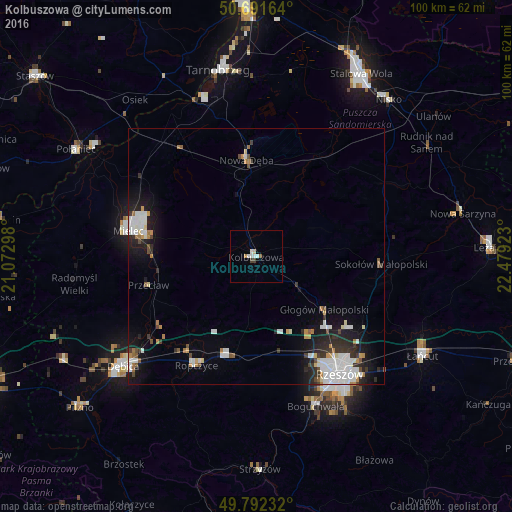
Analysis of Kolbuszowa night lights 2016
Square area 10x10 km:
 1.2%
1.2%90-99
1.47%80-89
0.53%70-79
0.27%60-69
0.27%50-59
0.53%40-49
0.67%30-39
0.4%20-29
0%10-19
0%0-9
94.65%Square area 50x50 km:
1.48%90-99
1.51%80-89
0.36%70-79
0.51%60-69
0.53%50-59
0.39%40-49
0.5%30-39
0.66%20-29
1.52%10-19
3.73%0-9
88.81%Clear (daylight) street map image can be seen on geolist.org.
Map coordinates:
50° 41' 29.9" North, 21° 4' 22.7" East
50° 14' 38.8" North, 21° 46' 34" East
49° 47' 32.4" North, 22° 28' 45.2" East
Some cities around Kolbuszowa sort by population:
• Rzeszów
27.6 km =17.1 mi,  144°
144°
• Mielec
25.5 km =15.8 mi,  280°
280°
• Ropczyce
24.4 km =15.2 mi,  209°
209°
• Nowa Dęba
20.7 km =12.9 mi,  355°
355°
• Sędziszów Małopolski
20 km =12.4 mi,  195°
195°
• Boguchwała
31.3 km =19.4 mi,  157°
157°
• Głogów Małopolski
16.8 km =10.4 mi,  127°
127°
• Jeżowe
28.9 km =18 mi,  59°
59°
768805 (p: 10,442)
Sources (retrieved 2019-11-25):
» Earth at Night: Flat Maps 2012, 2016