Poddębice night lights from space
Night Light of Poddębice (Łódź Voivodeship) from space (Poland) Src. Average luminocity for 10x10km area is 1.5417% and for 50x50km: 1.8172%.
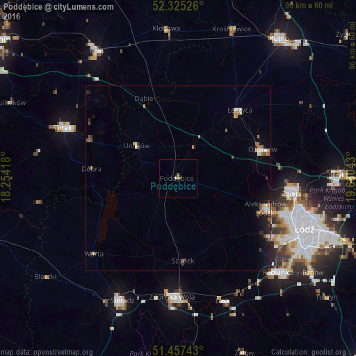
Analysis of Poddębice night lights 2016
Square area 10x10 km:
 0%
0%90-99
0.51%80-89
0%70-79
0.25%60-69
0.25%50-59
1.01%40-49
0%30-39
0%20-29
0%10-19
0%0-9
97.98%Square area 50x50 km:
0.19%90-99
0.23%80-89
0.18%70-79
0.22%60-69
0.33%50-59
0.3%40-49
0.21%30-39
0.21%20-29
0.29%10-19
1.25%0-9
96.6%Clear (daylight) street map image can be seen on geolist.org.
Map coordinates:
52° 19' 30.9" North, 18° 15' 15" East
51° 53' 36.4" North, 18° 57' 26.3" East
51° 27' 26.7" North, 19° 39' 37.5" East
Some cities around Poddębice sort by population:
• Zgierz
31.1 km =19.3 mi,  97°
97°
• Zduńska Wola
32.7 km =20.3 mi,  182°
182°
• Turek
34.1 km =21.2 mi,  293°
293°
• Ozorków
24.2 km =15 mi,  71°
71°
• Aleksandrów Łódzki
25.2 km =15.7 mi,  109°
109°
• Łask
35.8 km =22.2 mi,  160°
160°
• Konstantynów Łódzki
30.1 km =18.7 mi,  122°
122°
• Łęczyca
24.8 km =15.4 mi,  41°
41°
3088710 (p: 7,840)
Sources (retrieved 2019-11-25):
» Earth at Night: Flat Maps 2012, 2016