Nowa Dęba night lights from space
Night Light of Nowa Dęba (Subcarpathia) from space (Poland) Src. Average luminocity for 10x10km area is 4.6064% and for 50x50km: 4.4645%.
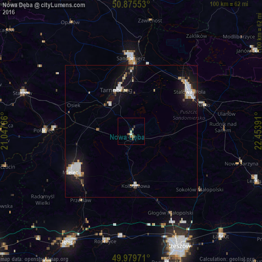
Analysis of Nowa Dęba night lights 2016
Square area 10x10 km:
 0.42%
0.42%90-99
0.14%80-89
0.56%70-79
0.98%60-69
1.26%50-59
0.7%40-49
1.82%30-39
0.28%20-29
0%10-19
0.56%0-9
93.28%Square area 50x50 km:
0.96%90-99
0.97%80-89
0.37%70-79
0.29%60-69
0.44%50-59
0.27%40-49
0.4%30-39
0.26%20-29
0.52%10-19
4.78%0-9
90.75%Clear (daylight) street map image can be seen on geolist.org.
Map coordinates:
50° 52' 31.9" North, 21° 2' 51.6" East
50° 25' 47.1" North, 21° 45' 2.8" East
49° 58' 47" North, 22° 27' 14.1" East
Some cities around Nowa Dęba sort by population:
• Stalowa Wola
27.3 km =17 mi,  51°
51°
• Mielec
28.1 km =17.5 mi,  235°
235°
• Tarnobrzeg
16.7 km =10.4 mi,  342°
342°
• Sandomierz
28.1 km =17.5 mi,  359°
359°
• Nisko
29.3 km =18.2 mi,  69°
69°
• Kolbuszowa
20.7 km =12.9 mi,  175°
175°
• Gorzyce
27.1 km =16.8 mi,  13°
13°
• Jeżowe
27.4 km =17 mi,  102°
102°
763783 (p: 11,489)
Sources (retrieved 2019-11-25):
» Earth at Night: Flat Maps 2012, 2016