Łomianki night lights from space
Night Light of Łomianki (Mazovia) from space (Poland) Src. Average luminocity for 10x10km area is 60.7879% and for 50x50km: 37.8304%.
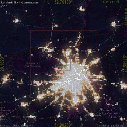
Analysis of Łomianki night lights 2016
Square area 10x10 km:
100  17.17%
90-99 16.29%
80-89 5.05%
70-79 6.19%
60-69 5.81%
50-59 3.03%
40-49 9.34%
30-39 12.88%
20-29 13.51%
10-19 10.23%
0-9 0.51%
17.17%90-99
16.29%80-89
5.05%70-79
6.19%60-69
5.81%50-59
3.03%40-49
9.34%30-39
12.88%20-29
13.51%10-19
10.23%0-9
0.51%Square area 50x50 km:
100 13.19%
90-99 8.58%
80-89 2.84%
70-79 3.4%
60-69 3.68%
50-59 3.72%
40-49 3.8%
30-39 4.03%
20-29 7.1%
10-19 9.93%
0-9 39.72%
13.19%90-99
8.58%80-89
2.84%70-79
3.4%60-69
3.68%50-59
3.72%40-49
3.8%30-39
4.03%20-29
7.1%10-19
9.93%0-9
39.72%Clear (daylight) street map image can be seen on geolist.org.
Map coordinates:
52° 45' 42.1" North, 20° 10' 58.4" East
52° 20' 2.9" North, 20° 53' 9.7" East
51° 54' 8.6" North, 21° 35' 20.9" East
Some cities around Łomianki sort by population:
• Wola
12.6 km =7.8 mi,  146°
146°
• Bielany
5.7 km =3.5 mi,  144°
144°
• Targówek
12 km =7.5 mi,  113°
113°
• Bemowo
9 km =5.6 mi,  170°
170°
• Białołeka
6 km =3.7 mi,  103°
103°
• Żoliborz
10 km =6.2 mi, 136°
• Legionowo
8 km =5 mi,  20°
20°
• Jabłonna
5.4 km =3.4 mi, 23°
766042 (p: 15,315)
Sources (retrieved 2019-11-25):
» Earth at Night: Flat Maps 2012, 2016