Lipno night lights from space
Night Light of Lipno (Kujawsko-Pomorskie) from space (Poland) Src. Average luminocity for 10x10km area is 6.7298% and for 50x50km: 3.1567%.
Analysis of Lipno night lights 2016
Square area 10x10 km:
 0.76%
0.76%90-99
1.64%80-89
1.64%70-79
0%60-69
0.51%50-59
1.01%40-49
0.51%30-39
0.51%20-29
0.51%10-19
0%0-9
92.93%Square area 50x50 km:
0.59%90-99
0.58%80-89
0.37%70-79
0.2%60-69
0.25%50-59
0.35%40-49
0.25%30-39
0.27%20-29
0.61%10-19
3%0-9
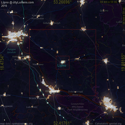
93.53%Clear (daylight) street map image can be seen on geolist.org.
Map coordinates:
53° 16' 1.1" North, 18° 28' 31.4" East
52° 50' 39.7" North, 19° 10' 42.7" East
52° 25' 3.4" North, 19° 52' 53.9" East
Some cities around Lipno sort by population:
• Toruń
43.2 km =26.8 mi,  295°
295°
• Włocławek
23.1 km =14.4 mi,  198°
198°
• Brodnica
48.4 km =30.1 mi,  17°
17°
• Sierpc
33 km =20.5 mi,  87°
87°
• Rypin
29.1 km =18.1 mi,  32°
32°
• Golub-Dobrzyń
30.8 km =19.1 mi,  344°
344°
• Aleksandrów Kujawski
32.8 km =20.4 mi,  276°
276°
• Ciechocinek
26 km =16.2 mi, 278°
3093268 (p: 14,821)
Sources (retrieved 2019-11-25):
» Earth at Night: Flat Maps 2012, 2016