Limanowa night lights from space
Night Light of Limanowa (Lesser Poland) from space (Poland) Src. Average luminocity for 10x10km area is 10.3543% and for 50x50km: 4.0015%.
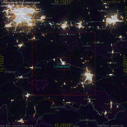
Analysis of Limanowa night lights 2016
Square area 10x10 km:
 1.6%
1.6%90-99
1.74%80-89
1.87%70-79
1.74%60-69
0%50-59
0.53%40-49
1.07%30-39
1.34%20-29
1.34%10-19
0.53%0-9
88.24%Square area 50x50 km:
0.51%90-99
0.73%80-89
0.36%70-79
0.36%60-69
0.4%50-59
0.6%40-49
0.6%30-39
0.73%20-29
0.96%10-19
2.44%0-9
92.31%Clear (daylight) street map image can be seen on geolist.org.
Map coordinates:
50° 9' 30.7" North, 19° 43' 8.1" East
49° 42' 21.4" North, 20° 25' 19.3" East
49° 14' 56.7" North, 21° 7' 30.6" East
Some cities around Limanowa sort by population:
• Nowy Sącz
21.9 km =13.6 mi,  115°
115°
• Bochnia
29.3 km =18.2 mi,  1°
1°
• Brzesko
32.1 km =19.9 mi,  24°
24°
• Rabka-Zdrój
34.5 km =21.4 mi,  251°
251°
• Stary Sącz
22 km =13.7 mi,  135°
135°
• Mszana Dolna
24.9 km =15.5 mi,  261°
261°
• Dobczyce
30.8 km =19.1 mi,  309°
309°
• Szczawnica
31.6 km =19.6 mi,  171°
171°
766301 (p: 14,714)
Sources (retrieved 2019-11-25):
» Earth at Night: Flat Maps 2012, 2016