Stary Sącz night lights from space
Night Light of Stary Sącz (Lesser Poland) from space (Poland) Src. Average luminocity for 10x10km area is 19.3403% and for 50x50km: 4.4538%.
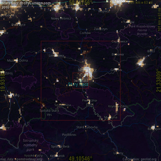
Analysis of Stary Sącz night lights 2016
Square area 10x10 km:
 2.1%
2.1%90-99
3.64%80-89
1.68%70-79
1.54%60-69
1.68%50-59
2.24%40-49
3.22%30-39
3.92%20-29
7.84%10-19
17.51%0-9
54.62%Square area 50x50 km:
0.55%90-99
0.82%80-89
0.52%70-79
0.38%60-69
0.53%50-59
0.61%40-49
0.77%30-39
0.73%20-29
0.92%10-19
2.43%0-9
91.75%Clear (daylight) street map image can be seen on geolist.org.
Map coordinates:
50° 1' 3.2" North, 19° 55' 54.6" East
49° 33' 49.1" North, 20° 38' 5.9" East
49° 6' 19.7" North, 21° 20' 17.1" East
Some cities around Stary Sącz sort by population:
• Nowy Sącz
7.9 km =4.9 mi,  34°
34°
• Stará Ľubovňa, SK
29.7 km =18.5 mi,  172°
172°
• Limanowa
22 km =13.7 mi,  315°
315°
• Krynica-Zdrój
28.2 km =17.5 mi,  123°
123°
• Szczawnica
18.9 km =11.7 mi,  214°
214°
• Grybów
23.5 km =14.6 mi,  73°
73°
• Piwniczna-Zdrój
14.8 km =9.2 mi,  157°
157°
• Muszyna
29.8 km =18.5 mi,  140°
140°
758282 (p: 8,959)
Sources (retrieved 2019-11-25):
» Earth at Night: Flat Maps 2012, 2016