Rabka-Zdrój night lights from space
Night Light of Rabka-Zdrój (Lesser Poland) from space (Poland) Src. Average luminocity for 10x10km area is 4.8613% and for 50x50km: 1.2138%.
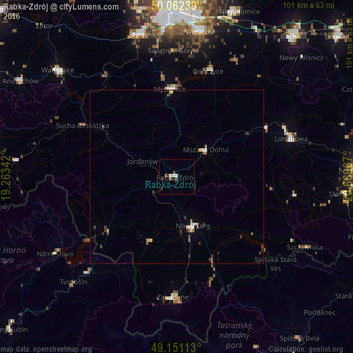
Analysis of Rabka-Zdrój night lights 2016
Square area 10x10 km:
 1.12%
1.12%90-99
1.12%80-89
0%70-79
0%60-69
0%50-59
1.82%40-49
0.56%30-39
0.42%20-29
1.68%10-19
0.14%0-9
93.14%Square area 50x50 km:
0.15%90-99
0.18%80-89
0.12%70-79
0.1%60-69
0.13%50-59
0.22%40-49
0.23%30-39
0.34%20-29
0.13%10-19
0.09%0-9
98.31%Clear (daylight) street map image can be seen on geolist.org.
Map coordinates:
50° 3' 44.6" North, 19° 15' 48.3" East
49° 36' 32" North, 19° 57' 59.5" East
49° 9' 4.1" North, 20° 40' 10.8" East
Some cities around Rabka-Zdrój sort by population:
• Nowy Targ
15.3 km =9.5 mi,  161°
161°
• Myślenice
25.1 km =15.6 mi,  355°
355°
• Sucha Beskidzka
30.6 km =19 mi,  298°
298°
• Mszana Dolna
10.9 km =6.8 mi,  48°
48°
• Sułkowice
28.4 km =17.6 mi,  335°
335°
• Zawoja
30.8 km =19.1 mi,  277°
277°
• Maków Podhalański
24.8 km =15.4 mi, 302°
• Jordanów
10.8 km =6.7 mi,  294°
294°
3087601 (p: 13,071)
Sources (retrieved 2019-11-25):
» Earth at Night: Flat Maps 2012, 2016