Mszana Dolna night lights from space
Night Light of Mszana Dolna (Lesser Poland) from space (Poland) Src. Average luminocity for 10x10km area is 3.496% and for 50x50km: 1.9123%.
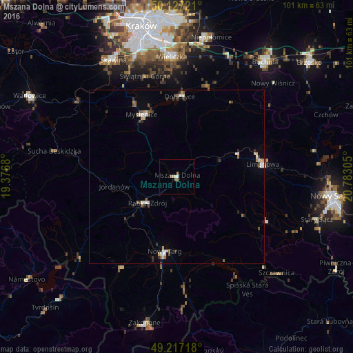
Analysis of Mszana Dolna night lights 2016
Square area 10x10 km:
 0.67%
0.67%90-99
0.4%80-89
0.53%70-79
0.53%60-69
1.6%50-59
0%40-49
0%30-39
0%20-29
0%10-19
0%0-9
96.26%Square area 50x50 km:
0.3%90-99
0.34%80-89
0.12%70-79
0.21%60-69
0.17%50-59
0.36%40-49
0.24%30-39
0.37%20-29
0.2%10-19
0.13%0-9
97.57%Clear (daylight) street map image can be seen on geolist.org.
Map coordinates:
50° 7' 38" North, 19° 22' 36.5" East
49° 40' 27.6" North, 20° 4' 47.7" East
49° 13' 1.8" North, 20° 46' 59" East
Some cities around Mszana Dolna sort by population:
• Nowy Targ
22.1 km =13.7 mi,  188°
188°
• Myślenice
20.4 km =12.7 mi,  330°
330°
• Limanowa
24.9 km =15.5 mi,  81°
81°
• Rabka-Zdrój
10.9 km =6.8 mi,  228°
228°
• Sułkowice
27.3 km =17 mi,  312°
312°
• Dobczyce
23 km =14.3 mi,  1°
1°
• Maków Podhalański
29.6 km =18.4 mi,  282°
282°
• Jordanów
18.2 km =11.3 mi,  261°
261°
764276 (p: 7,500)
Sources (retrieved 2019-11-25):
» Earth at Night: Flat Maps 2012, 2016